


NHC Graphical Outlook Archive
|
« Earliest Available ‹ Earlier Later › Latest Available » |
GIS Shapefiles |
| Eastern Pacific | Atlantic |
|
Tropical Weather Outlook Text
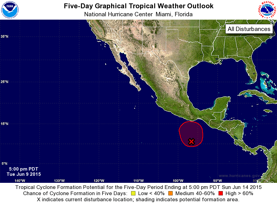
ZCZC MIATWOEP ALL
TTAA00 KNHC DDHHMM

TROPICAL WEATHER OUTLOOK
NWS NATIONAL HURRICANE CENTER MIAMI FL
500 PM PDT TUE JUN 9 2015

For the eastern North Pacific...east of 140 degrees west longitude:

1. Showers and thunderstorms associated with a low pressure area
several hundred miles south of the Gulf of Tehuantepec have changed
little in organization over the past 24 hours. However,
environmental conditions appear to be conducive for a tropical
depression to form during the next couple of days while this system
moves slowly northwestward or northward.
* Formation chance through 48 hours...medium...60 percent
* Formation chance through 5 days...high...90 percent

Forecaster Beven
List of Atlantic Outlooks (May 2023 - present)
List of East Pacific Outlooks (May 2023 - present)
List of Central Pacific Outlooks (May 2023 - present)
List of Atlantic Outlooks (July 2014 - April 2023)
List of East Pacific Outlooks (July 2014 - April 2023)
List of Central Pacific Outlooks (June 2019 - April 2023)
List of Atlantic Outlooks (June 2009 - June 2014)
List of East Pacific Outlooks (June 2009 - June 2014)