


NHC Graphical Outlook Archive
|
« Earliest Available ‹ Earlier Later › Latest Available » |
GIS Shapefiles |
| Eastern Pacific | Atlantic |
|
Tropical Weather Outlook Text
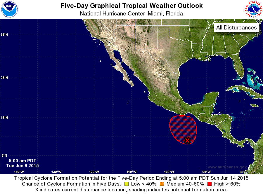
ZCZC MIATWOEP ALL
TTAA00 KNHC DDHHMM

TROPICAL WEATHER OUTLOOK
NWS NATIONAL HURRICANE CENTER MIAMI FL
500 AM PDT TUE JUN 9 2015

For the eastern North Pacific...east of 140 degrees west longitude:

The National Hurricane Center has issued the last advisory on
Post-Tropical Cyclone Blanca, located near the central portion of
the Baja California peninsula.

1. Although the associated shower activity has recently decreased,
satellite data indicate that the area of low pressure several
hundred miles south of Gulf Tehuantepec has become better defined
since yesterday.  Environmental conditions remain conducive for a
tropical depression to form during the next couple of days while
this system moves slowly northwestward or northward.
* Formation chance through 48 hours...medium...60 percent
* Formation chance through 5 days...high...90 percent

Forecaster Blake
List of Atlantic Outlooks (May 2023 - present)
List of East Pacific Outlooks (May 2023 - present)
List of Central Pacific Outlooks (May 2023 - present)
List of Atlantic Outlooks (July 2014 - April 2023)
List of East Pacific Outlooks (July 2014 - April 2023)
List of Central Pacific Outlooks (June 2019 - April 2023)
List of Atlantic Outlooks (June 2009 - June 2014)
List of East Pacific Outlooks (June 2009 - June 2014)