


NHC Graphical Outlook Archive
|
« Earliest Available ‹ Earlier Later › Latest Available » |
GIS Shapefiles |
| Eastern Pacific | Atlantic |
|
Tropical Weather Outlook Text
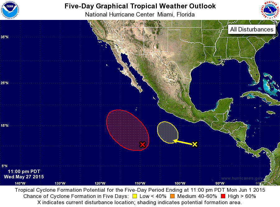
ZCZC MIATWOEP ALL
TTAA00 KNHC DDHHMM

TROPICAL WEATHER OUTLOOK
NWS NATIONAL HURRICANE CENTER MIAMI FL
1100 PM PDT WED MAY 27 2015

For the eastern North Pacific...east of 140 degrees west longitude:

1. A low pressure system located about 675 miles south-southwest of
Manzanillo, Mexico, has continued to become better organized during
the past several hours, and satellite images indicate that a
tropical depression could be forming.  Advisories could be initiated
on this system as early as Thursday morning if this trend continues.
The low is expected to move west-northwestward at about 10 mph well
offshore the coast of Mexico during the next few days.
* Formation chance through 48 hours...high...90 percent
* Formation chance through 5 days...high...90 percent

2. An area of disturbed weather located several hundred miles south-
southwest of the Gulf of Tehuantepec is associated with a tropical
wave.  Environmental conditions could become more favorable for some
development of this system by the weekend while it moves slowly to
the west-northwest.
* Formation chance through 48 hours...low...near 0 percent
* Formation chance through 5 days...low...20 percent

Forecaster Berg
List of Atlantic Outlooks (May 2023 - present)
List of East Pacific Outlooks (May 2023 - present)
List of Central Pacific Outlooks (May 2023 - present)
List of Atlantic Outlooks (July 2014 - April 2023)
List of East Pacific Outlooks (July 2014 - April 2023)
List of Central Pacific Outlooks (June 2019 - April 2023)
List of Atlantic Outlooks (June 2009 - June 2014)
List of East Pacific Outlooks (June 2009 - June 2014)