


NHC Graphical Outlook Archive
|
« Earliest Available ‹ Earlier Later › Latest Available » |
GIS Shapefiles |
| Eastern Pacific | Atlantic |
|
Tropical Weather Outlook Text
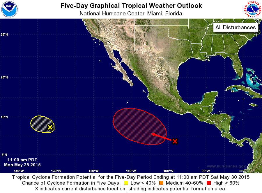
ZCZC MIATWOEP ALL
TTAA00 KNHC DDHHMM

TROPICAL WEATHER OUTLOOK
NWS NATIONAL HURRICANE CENTER MIAMI FL
1100 AM PDT MON MAY 25 2015

For the eastern North Pacific...east of 140 degrees west longitude:

1. A nearly-stationary area of low pressure located about 1600 miles
west-southwest of the southern tip of Baja California is producing
a concentrated area of disorganized thunderstorms well away from
the low's circulation center. Satellite data indicate that the
circulation has become less defined since yesterday, and
environmental conditions are expected to continue to become less
conducive for development.
* Formation chance through 48 hours...low...20 percent
* Formation chance through 5 days...low...20 percent

2. An area of disturbed weather has formed several hundred miles south
of the coast of Mexico.  Environmental conditions appear conducive
for gradual development of this system during the next several
days, and a tropical depression is likely to form after mid-week
while the disturbance moves slowly west-northwestward to
northwestward.
* Formation chance through 48 hours...low...near 10 percent
* Formation chance through 5 days...high...70 percent

Forecaster Brown
List of Atlantic Outlooks (May 2023 - present)
List of East Pacific Outlooks (May 2023 - present)
List of Central Pacific Outlooks (May 2023 - present)
List of Atlantic Outlooks (July 2014 - April 2023)
List of East Pacific Outlooks (July 2014 - April 2023)
List of Central Pacific Outlooks (June 2019 - April 2023)
List of Atlantic Outlooks (June 2009 - June 2014)
List of East Pacific Outlooks (June 2009 - June 2014)