


NHC Graphical Outlook Archive
|
« Earliest Available ‹ Earlier Later › Latest Available » |
GIS Shapefiles |
| Eastern Pacific | Atlantic |
|
|
(mouse over shaded areas for details; click on shaded areas or disturbance numbers to switch views) |
Tropical Weather Outlook Text
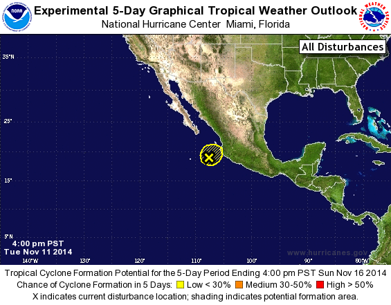
TROPICAL WEATHER OUTLOOK
NWS NATIONAL HURRICANE CENTER MIAMI FL
400 PM PST TUE NOV 11 2014

For the eastern North Pacific...east of 140 degrees west longitude:

1. A low pressure area located about 175 miles west of Manzanillo,
Mexico, is producing disorganized showers and thunderstorms well to
its northeast, near the southwestern coast of Mexico.  This system
has become less organized today, and development is not expected due
to strong upper-level winds. However, locally heavy rains and gusty
winds could continue over portions of southwestern Mexico tonight
while the low drifts eastward or northeastward.
* Formation chance through 48 hours...low...10 percent.
* Formation chance through 5 days...low...10 percent.

Forecaster Brown
List of Atlantic Outlooks (May 2023 - present)
List of East Pacific Outlooks (May 2023 - present)
List of Central Pacific Outlooks (May 2023 - present)
List of Atlantic Outlooks (July 2014 - April 2023)
List of East Pacific Outlooks (July 2014 - April 2023)
List of Central Pacific Outlooks (June 2019 - April 2023)
List of Atlantic Outlooks (June 2009 - June 2014)
List of East Pacific Outlooks (June 2009 - June 2014)