


NHC Graphical Outlook Archive
|
« Earliest Available ‹ Earlier Later › Latest Available » |
GIS Shapefiles |
| Eastern Pacific | Atlantic |
|
|
(mouse over shaded areas for details; click on shaded areas or disturbance numbers to switch views) |
Tropical Weather Outlook Text
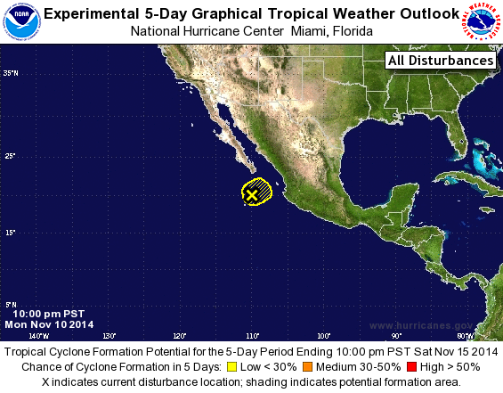
TROPICAL WEATHER OUTLOOK
NWS NATIONAL HURRICANE CENTER MIAMI FL
1000 PM PST MON NOV 10 2014

For the eastern North Pacific...east of 140 degrees west longitude:

1. During the past several hours, shower and thunderstorm activity has
continued to become less organized in association with an area of
low pressure located about 200 miles south of the southern tip of
the Baja California peninsula.  Upper-level winds are expected to
steadily increase and become unfavorable for tropical cyclone
formation to occur. Regardless of development, this system could
bring locally heavy rainfall and gusty winds to portions of the
west coast of mainland Mexico through Tuesday while it moves
northeastward at about 10 mph.
* Formation chance through 48 hours...low...20 percent.
* Formation chance through 5 days...low...20 percent.

Forecaster Stewart
List of Atlantic Outlooks (May 2023 - present)
List of East Pacific Outlooks (May 2023 - present)
List of Central Pacific Outlooks (May 2023 - present)
List of Atlantic Outlooks (July 2014 - April 2023)
List of East Pacific Outlooks (July 2014 - April 2023)
List of Central Pacific Outlooks (June 2019 - April 2023)
List of Atlantic Outlooks (June 2009 - June 2014)
List of East Pacific Outlooks (June 2009 - June 2014)