


NHC Graphical Outlook Archive
|
« Earliest Available ‹ Earlier Later › Latest Available » |
| Eastern Pacific | Atlantic |
|
|
(mouse over shaded areas for details; click on shaded areas or disturbance numbers to switch views) |
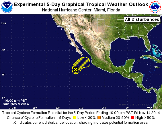
Tropical Weather Outlook Text
TROPICAL WEATHER OUTLOOK
NWS NATIONAL HURRICANE CENTER MIAMI FL
1000 PM PST SUN NOV 9 2014

For the eastern North Pacific...east of 140 degrees west longitude:

1. A low pressure system located about 450 miles south of the
southern tip of the Baja California peninsula, or also about 150
miles south-southwest of Socorro Island, is gradually becoming
better defined.  Shower and thunderstorm activity has become a
little better organized during the past few hours and some further
development of this low is possible later today while the system
moves slowly north-northeastward to northeastward.  However,
environmental conditions are forecast to become unfavorable for
tropical cyclone formation by Monday night or Tuesday morning.
* Formation chance through 48 hours...low...20 percent.
* Formation chance through 5 days...low...20 percent.

Forecaster Stewart
List of Atlantic Outlooks (May 2023 - present)
List of East Pacific Outlooks (May 2023 - present)
List of Central Pacific Outlooks (May 2023 - present)
List of Atlantic Outlooks (July 2014 - April 2023)
List of East Pacific Outlooks (July 2014 - April 2023)
List of Central Pacific Outlooks (June 2019 - April 2023)
List of Atlantic Outlooks (June 2009 - June 2014)
List of East Pacific Outlooks (June 2009 - June 2014)