


NHC Graphical Outlook Archive
|
« Earliest Available ‹ Earlier Later › Latest Available » |
| Eastern Pacific | Atlantic |
|
|
(mouse over shaded areas for details; click on shaded areas or disturbance numbers to switch views) |
Tropical Weather Outlook Text
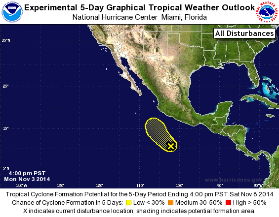
TROPICAL WEATHER OUTLOOK
NWS NATIONAL HURRICANE CENTER MIAMI FL
400 PM PST MON NOV 3 2014

For the eastern North Pacific...east of 140 degrees west longitude:

The National Hurricane Center is issuing advisories on Hurricane
Vance, located more than a hundred miles south of Socorro Island.

1. A small area of low pressure located several hundred miles
southwest of Acapulco, Mexico, continues to produce disorganized
showers and thunderstorms.  Development, if any, of this system
should be slow to occur during the next day or two while it moves
west-northwestward to northwestward at about 15 mph.  After that
time, development is not expected due to strong upper-level winds
and interaction with Hurricane Vance's circulation.
* Formation chance through 48 hours...low...20 percent.
* Formation chance through 5 days...low...20 percent.

Forecaster Stewart
List of Atlantic Outlooks (May 2023 - present)
List of East Pacific Outlooks (May 2023 - present)
List of Central Pacific Outlooks (May 2023 - present)
List of Atlantic Outlooks (July 2014 - April 2023)
List of East Pacific Outlooks (July 2014 - April 2023)
List of Central Pacific Outlooks (June 2019 - April 2023)
List of Atlantic Outlooks (June 2009 - June 2014)
List of East Pacific Outlooks (June 2009 - June 2014)