


NHC Graphical Outlook Archive
|
« Earliest Available ‹ Earlier Later › Latest Available » |
| Eastern Pacific | Atlantic |
|
|
(mouse over shaded areas for details; click on shaded areas or disturbance numbers to switch views) |
Tropical Weather Outlook Text
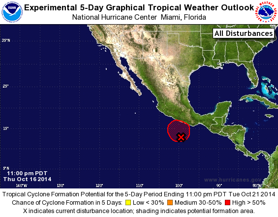
TROPICAL WEATHER OUTLOOK
NWS NATIONAL HURRICANE CENTER MIAMI FL
1100 PM PDT THU OCT 16 2014

For the eastern North Pacific...east of 140 degrees west longitude:

1. A trough of low pressure extending from the Gulf of Tehuantepec
southwestward for several hundred miles continues to produce a large
area of disorganized cloudiness and thunderstorms. Slow development
of this system is possible during the next couple of days while the
trough moves slowly northward or northwestward toward the coast of
southern Mexico.  Regardless of the potential for tropical cyclone
formation, heavy rainfall and localized flooding associated
with this disturbance could produce flash flooding and mudslides in
portions of southern Mexico, especially near areas of elevated
terrain, beginning this weekend.
* Formation chance through 48 hours...medium...50 percent.
* Formation chance through 5 days...high...60 percent.

Forecaster Kimberlain
List of Atlantic Outlooks (May 2023 - present)
List of East Pacific Outlooks (May 2023 - present)
List of Central Pacific Outlooks (May 2023 - present)
List of Atlantic Outlooks (July 2014 - April 2023)
List of East Pacific Outlooks (July 2014 - April 2023)
List of Central Pacific Outlooks (June 2019 - April 2023)
List of Atlantic Outlooks (June 2009 - June 2014)
List of East Pacific Outlooks (June 2009 - June 2014)