


NHC Graphical Outlook Archive
|
« Earliest Available ‹ Earlier Later › Latest Available » |
| Eastern Pacific | Atlantic |
|
|
(mouse over shaded areas for details; click on shaded areas or disturbance numbers to switch views) |
Tropical Weather Outlook Text
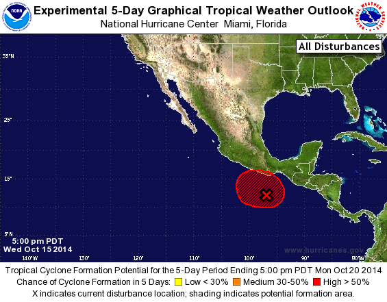
TROPICAL WEATHER OUTLOOK
NWS NATIONAL HURRICANE CENTER MIAMI FL
500 PM PDT WED OCT 15 2014

For the eastern North Pacific...east of 140 degrees west longitude:

1. A large area of disturbed weather extending from the Gulf of
Tehuantepec southwestward for a few hundred miles is associated
with an elongated area of low pressure.  This disturbance is showing
signs of organization, and the environment appears to be favorable
for the formation of a tropical depression during the next day or
so.  This system is expected to move northwestward or northward
toward the coast of Mexico, and regardless of whether or not a
tropical cyclone forms, heavy rains will spread across southwestern
Mexico over the next few days. These rains could cause
life-threatening flash floods and mud slides.
* Formation chance through 48 hours...high...60 percent.
* Formation chance through 5 days...high...70 percent.

Forecaster Avila
List of Atlantic Outlooks (May 2023 - present)
List of East Pacific Outlooks (May 2023 - present)
List of Central Pacific Outlooks (May 2023 - present)
List of Atlantic Outlooks (July 2014 - April 2023)
List of East Pacific Outlooks (July 2014 - April 2023)
List of Central Pacific Outlooks (June 2019 - April 2023)
List of Atlantic Outlooks (June 2009 - June 2014)
List of East Pacific Outlooks (June 2009 - June 2014)