


NHC Graphical Outlook Archive
|
« Earliest Available ‹ Earlier Later › Latest Available » |
| Eastern Pacific | Atlantic |
|
|
(mouse over shaded areas for details; click on shaded areas or disturbance numbers to switch views) |
Tropical Weather Outlook Text
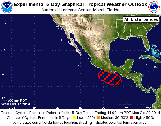
TROPICAL WEATHER OUTLOOK
NWS NATIONAL HURRICANE CENTER MIAMI FL
1100 AM PDT WED OCT 15 2014

For the eastern North Pacific...east of 140 degrees west longitude:

1. Extensive but disorganized shower activity continues in association
with an elongated area of low pressure located a few hundred miles
south and southwest of the Gulf of Tehuantepec.  Upper-level winds
are favorable for development, and a gradual consolidation of this
system into a tropical depression is possible over the next couple
of days as it moves slowly west-northwestward or northwestward.
Regardless of whether or not a tropical cyclone forms, shower
activity is likely to spread toward and across the southwestern
coast of Mexico over the next few days.
* Formation chance through 48 hours...medium...50 percent.
* Formation chance through 5 days...high...60 percent.

Forecaster Franklin
List of Atlantic Outlooks (May 2023 - present)
List of East Pacific Outlooks (May 2023 - present)
List of Central Pacific Outlooks (May 2023 - present)
List of Atlantic Outlooks (July 2014 - April 2023)
List of East Pacific Outlooks (July 2014 - April 2023)
List of Central Pacific Outlooks (June 2019 - April 2023)
List of Atlantic Outlooks (June 2009 - June 2014)
List of East Pacific Outlooks (June 2009 - June 2014)