


NHC Graphical Outlook Archive
|
« Earliest Available ‹ Earlier Later › Latest Available » |
| Eastern Pacific | Atlantic |
|
|
(mouse over shaded areas for details; click on shaded areas or disturbance numbers to switch views) |
Tropical Weather Outlook Text
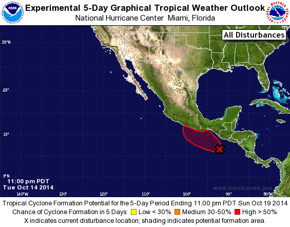
TROPICAL WEATHER OUTLOOK
NWS NATIONAL HURRICANE CENTER MIAMI FL
1100 PM PDT TUE OCT 14 2014

For the eastern North Pacific...east of 140 degrees west longitude:

1. A broad area of low pressure located a couple of hundred miles
south-southwest of the coast of Guatemala is producing a large
area of disorganized showers and thunderstorms.  Environmental
conditions are expected to be conducive for gradual development
during the next few days, and this system has the potential to
become a tropical depression by late this week.  The low is
forecast to move slowly northwestward toward the coast of
southeastern Mexico.
* Formation chance through 48 hours...medium...40 percent.
* Formation chance through 5 days...high...60 percent.

Forecaster Brown
List of Atlantic Outlooks (May 2023 - present)
List of East Pacific Outlooks (May 2023 - present)
List of Central Pacific Outlooks (May 2023 - present)
List of Atlantic Outlooks (July 2014 - April 2023)
List of East Pacific Outlooks (July 2014 - April 2023)
List of Central Pacific Outlooks (June 2019 - April 2023)
List of Atlantic Outlooks (June 2009 - June 2014)
List of East Pacific Outlooks (June 2009 - June 2014)