


NHC Graphical Outlook Archive
|
« Earliest Available ‹ Earlier Later › Latest Available » |
| Eastern Pacific | Atlantic |
|
|
(mouse over shaded areas for details; click on shaded areas or disturbance numbers to switch views) |
Tropical Weather Outlook Text
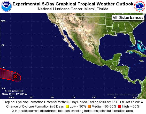
TROPICAL WEATHER OUTLOOK
NWS NATIONAL HURRICANE CENTER MIAMI FL
500 AM PDT SUN OCT 12 2014

For the eastern North Pacific...east of 140 degrees west longitude:

1. Shower and thunderstorm activity has become better organized in
association with a low pressure system located about 1300 miles
east-southeast of the Hawaiian Islands. Environmental conditions are
expected to be conducive for development of this disturbance during
the next several days while it moves westward or west-northwestward
at around 10 to 15 mph, and enters the central Pacific basin by
Monday morning.
* Formation chance through 48 hours...medium...50 percent.
* Formation chance through 5 days...high...80 percent.

Forecaster Stewart
List of Atlantic Outlooks (May 2023 - present)
List of East Pacific Outlooks (May 2023 - present)
List of Central Pacific Outlooks (May 2023 - present)
List of Atlantic Outlooks (July 2014 - April 2023)
List of East Pacific Outlooks (July 2014 - April 2023)
List of Central Pacific Outlooks (June 2019 - April 2023)
List of Atlantic Outlooks (June 2009 - June 2014)
List of East Pacific Outlooks (June 2009 - June 2014)