


NHC Graphical Outlook Archive
|
« Earliest Available ‹ Earlier Later › Latest Available » |
| Eastern Pacific | Atlantic |
|
|
(mouse over shaded areas for details; click on shaded areas or disturbance numbers to switch views) |
Tropical Weather Outlook Text
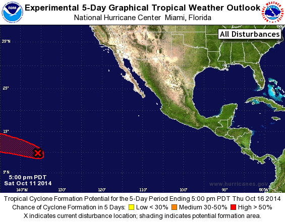
TROPICAL WEATHER OUTLOOK
NWS NATIONAL HURRICANE CENTER MIAMI FL
500 PM PDT SAT OCT 11 2014

For the eastern North Pacific...east of 140 degrees west longitude:

1. A broad low pressure area has formed about 1400 miles east-southeast
of the Hawaiian Islands and is producing some shower and
thunderstorm activity.  Environmental conditions are expected to
become increasingly conducive for development of this system during
the next several days while it moves westward or west-northwestward
at around 15 mph.
* Formation chance through 48 hours...low...20 percent.
* Formation chance through 5 days...high...60 percent.

Forecaster Blake
List of Atlantic Outlooks (May 2023 - present)
List of East Pacific Outlooks (May 2023 - present)
List of Central Pacific Outlooks (May 2023 - present)
List of Atlantic Outlooks (July 2014 - April 2023)
List of East Pacific Outlooks (July 2014 - April 2023)
List of Central Pacific Outlooks (June 2019 - April 2023)
List of Atlantic Outlooks (June 2009 - June 2014)
List of East Pacific Outlooks (June 2009 - June 2014)