


NHC Graphical Outlook Archive
|
« Earliest Available ‹ Earlier Later › Latest Available » |
| Eastern Pacific | Atlantic |
|
|
(mouse over shaded areas for details; click on shaded areas or disturbance numbers to switch views) |
Tropical Weather Outlook Text
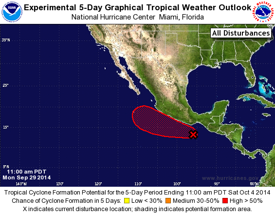
TROPICAL WEATHER OUTLOOK
NWS NATIONAL HURRICANE CENTER MIAMI FL
1100 AM PDT MON SEP 29 2014

For the eastern North Pacific...east of 140 degrees west longitude:

The National Hurricane Center is issuing advisories on Tropical
Storm Rachel, located several hundred miles west of the southern tip
of the Baja California peninsula.

1. Shower and thunderstorm activity associated with an area of low
pressure located several hundred miles southeast of Acapulco,
Mexico, has increased this morning. Environmental conditions are
conducive for additional development during the next several days,
and a tropical depression is likely to form later this week while
the system drifts west-northwestward or northwestward.  Regardless
of tropical cyclone formation, this disturbance could produce
locally heavy rains over portions of southern Mexico that could
cause flash floods and mud slides.
* Formation chance through 48 hours...low...20 percent.
* Formation chance through 5 days...high...80 percent.

Forecaster Kimberlain/Lewitsky
List of Atlantic Outlooks (May 2023 - present)
List of East Pacific Outlooks (May 2023 - present)
List of Central Pacific Outlooks (May 2023 - present)
List of Atlantic Outlooks (July 2014 - April 2023)
List of East Pacific Outlooks (July 2014 - April 2023)
List of Central Pacific Outlooks (June 2019 - April 2023)
List of Atlantic Outlooks (June 2009 - June 2014)
List of East Pacific Outlooks (June 2009 - June 2014)