


NHC Graphical Outlook Archive
|
« Earliest Available ‹ Earlier Later › Latest Available » |
| Eastern Pacific | Atlantic |
|
|
(mouse over shaded areas for details; click on shaded areas or disturbance numbers to switch views) |
Tropical Weather Outlook Text
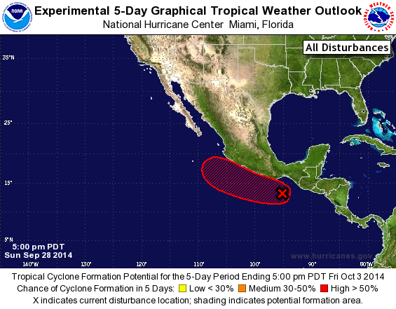
TROPICAL WEATHER OUTLOOK
NWS NATIONAL HURRICANE CENTER MIAMI FL
500 PM PDT SUN SEP 28 2014

For the eastern North Pacific...east of 140 degrees west longitude:

The National Hurricane Center is issuing advisories on Hurricane
Rachel, located several hundred miles west of the southern tip of
the Baja California peninsula.

1. A large area of disorganized showers and thunderstorms extending
from near the coast of southeastern Mexico southward for several
hundred miles is associated with an elongated area of low pressure.
Environmental conditions are expected to gradually become conducive
for development over the next several days, and a tropical
depression could form around the middle part of the week while the
system drifts west-northwestward or northwestward just offshore of
the south-central coast of Mexico.
* Formation chance through 48 hours...low...20 percent.
* Formation chance through 5 days...high...70 percent.

Forecaster Stewart
List of Atlantic Outlooks (May 2023 - present)
List of East Pacific Outlooks (May 2023 - present)
List of Central Pacific Outlooks (May 2023 - present)
List of Atlantic Outlooks (July 2014 - April 2023)
List of East Pacific Outlooks (July 2014 - April 2023)
List of Central Pacific Outlooks (June 2019 - April 2023)
List of Atlantic Outlooks (June 2009 - June 2014)
List of East Pacific Outlooks (June 2009 - June 2014)