


NHC Graphical Outlook Archive
|
« Earliest Available ‹ Earlier Later › Latest Available » |
| Eastern Pacific | Atlantic |
|
|
(mouse over shaded areas for details; click on shaded areas or disturbance numbers to switch views) |
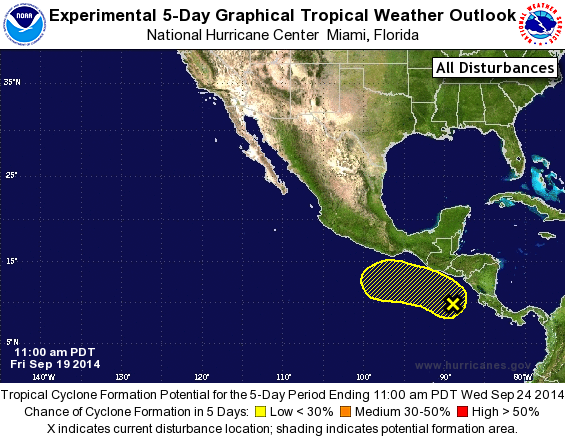
Tropical Weather Outlook Text
TROPICAL WEATHER OUTLOOK
NWS NATIONAL HURRICANE CENTER MIAMI FL
1100 AM PDT FRI SEP 19 2014

For the eastern North Pacific...east of 140 degrees west longitude:

The National Hurricane Center is issuing advisories on Tropical
Storm Polo, located a few hundred miles south-southeast of the
southern tip of the Baja California peninsula.  The Weather
Prediction Center in Washington, DC, is issuing advisories on the
remnants of Odile, located over the southwestern United States.

1. An area of low pressure could develop later this weekend or early
next week a few hundred miles south or southeast of the Gulf of
Tehuantepec.  Environmental conditions are conducive for some
gradual development later next week.
* Formation chance through 48 hours...low...near 0 percent.
* Formation chance through 5 days...low...20 percent.

Forecaster Kimberlain/Huffman
List of Atlantic Outlooks (May 2023 - present)
List of East Pacific Outlooks (May 2023 - present)
List of Central Pacific Outlooks (May 2023 - present)
List of Atlantic Outlooks (July 2014 - April 2023)
List of East Pacific Outlooks (July 2014 - April 2023)
List of Central Pacific Outlooks (June 2019 - April 2023)
List of Atlantic Outlooks (June 2009 - June 2014)
List of East Pacific Outlooks (June 2009 - June 2014)