


NHC Graphical Outlook Archive
|
« Earliest Available ‹ Earlier Later › Latest Available » |
| Eastern Pacific | Atlantic |
|
|
(mouse over shaded areas for details; click on shaded areas or disturbance numbers to switch views) |
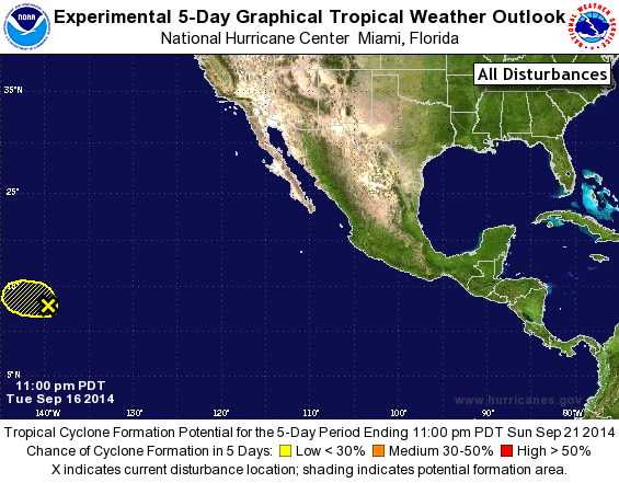
Tropical Weather Outlook Text
TROPICAL WEATHER OUTLOOK
NWS NATIONAL HURRICANE CENTER MIAMI FL
1100 PM PDT TUE SEP 16 2014

For the eastern North Pacific...east of 140 degrees west longitude:

The National Hurricane Center is issuing advisories on Tropical
Storm Odile, located over the northern Gulf of California, and on
Tropical Storm Polo, located a few hundred miles south of Acapulco,
Mexico.

1. Cloudiness and showers associated with a small area of low pressure
located about 1100 miles east-southeast of the Big Island of Hawaii
are currently minimal.  Abundant mid- and upper-level dry air near
the system is expected to prevent significant development while it
moves slowly west-northwestward or northwestward.
* Formation chance through 48 hours...low...near 0 percent.
* Formation chance through 5 days...low...near 0 percent.

Public Advisories on Tropical Storm Polo are issued under WMO header
WTPZ32 KNHC and under AWIPS header MIATCPEP2. Forecast/Advisories on
Tropical Storm Polo are issued under WMO header WTPZ22 KNHC and
under AWIPS header MIATCMEP2.

Forecaster Beven
List of Atlantic Outlooks (May 2023 - present)
List of East Pacific Outlooks (May 2023 - present)
List of Central Pacific Outlooks (May 2023 - present)
List of Atlantic Outlooks (July 2014 - April 2023)
List of East Pacific Outlooks (July 2014 - April 2023)
List of Central Pacific Outlooks (June 2019 - April 2023)
List of Atlantic Outlooks (June 2009 - June 2014)
List of East Pacific Outlooks (June 2009 - June 2014)