


NHC Graphical Outlook Archive
|
« Earliest Available ‹ Earlier Later › Latest Available » |
| Eastern Pacific | Atlantic |
|
|
(mouse over shaded areas for details; click on shaded areas or disturbance numbers to switch views) |
Tropical Weather Outlook Text
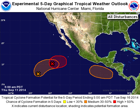
TROPICAL WEATHER OUTLOOK
NWS NATIONAL HURRICANE CENTER MIAMI FL
500 AM PDT THU SEP 11 2014

For the eastern North Pacific...east of 140 degrees west longitude:

The National Hurricane Center is issuing advisories on Tropical
Storm Odile, located about 200 miles south-southwest of Lazaro
Cardenas, Mexico.

1. A low pressure system located about 800 miles southwest of the
southern tip of the Baja California peninsula has changed little in
organization during the past few hours. However, only a slight
increase in organization would lead to the development of a tropical
depression, and advisories could still be initiated overnight or on
Thursday while the low moves northward at about 5 mph. The low is
forecast to turn eastward by Friday and could be absorbed by Odile
over the weekend.
* Formation chance through 48 hours...high...90 percent.
* Formation chance through 5 days...high...90 percent.

2. Showers and thunderstorms remain disorganized near a broad trough
of low pressure located about 1300 miles southwest of the southern
tip of the Baja California peninsula. Some development of this
system is possible during the next few days while it moves
northward and then northeastward at 5 to 10 mph.
* Formation chance through 48 hours...low...20 percent.
* Formation chance through 5 days...medium...30 percent.

3. An area of low pressure is expected to form south of the coasts of
Guatemala and El Salvador by late in the weekend. Conditions appear
favorable for some development of this system by early next week
while it moves slowly westward or west-northwestward.
* Formation chance through 48 hours...low...near 0 percent.
* Formation chance through 5 days...medium...30 percent.

Forecaster Beven
List of Atlantic Outlooks (May 2023 - present)
List of East Pacific Outlooks (May 2023 - present)
List of Central Pacific Outlooks (May 2023 - present)
List of Atlantic Outlooks (July 2014 - April 2023)
List of East Pacific Outlooks (July 2014 - April 2023)
List of Central Pacific Outlooks (June 2019 - April 2023)
List of Atlantic Outlooks (June 2009 - June 2014)
List of East Pacific Outlooks (June 2009 - June 2014)