


NHC Graphical Outlook Archive
|
« Earliest Available ‹ Earlier Later › Latest Available » |
| Eastern Pacific | Atlantic |
|
|
(mouse over shaded areas for details; click on shaded areas or disturbance numbers to switch views) |
Tropical Weather Outlook Text
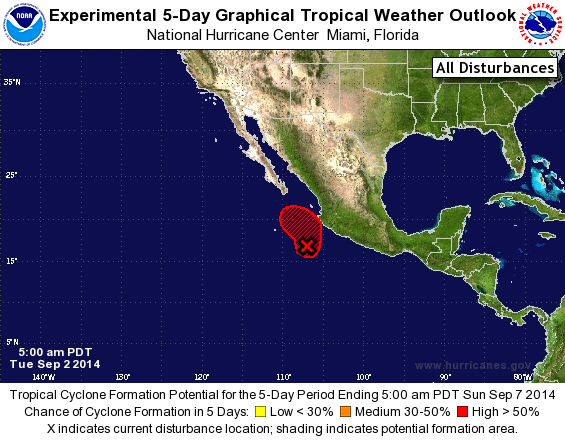
TROPICAL WEATHER OUTLOOK
NWS NATIONAL HURRICANE CENTER MIAMI FL
500 AM PDT TUE SEP 2 2014

For the eastern North Pacific...east of 140 degrees west longitude:

1. Showers and thunderstorms have recently increased near a low
pressure area producing gale-force winds, located about 200 miles
southwest of Manzanillo, Mexico.  If current trends continue,
advisories will be initiated on a tropical storm later this morning.
This system is expected to move slowly northward and then
northwestward near the southwestern coast of Mexico and the southern
Baja California peninsula during the next few days, and interests in
these areas should monitor the progress of the disturbance.  Locally
heavy rains could cause life-threatening flash floods and mud slides
over portions of southwestern Mexico during the next few days.
* Formation chance through 48 hours...high...near 100 percent.
* Formation chance through 5 days...high...near 100 percent.

For additional information on the low please see High Seas Forecasts
issued by the National Weather Service...under AWIPS header
NFDHSFEPI and WMO header FZPN01 KWBC.

Forecaster Blake
List of Atlantic Outlooks (May 2023 - present)
List of East Pacific Outlooks (May 2023 - present)
List of Central Pacific Outlooks (May 2023 - present)
List of Atlantic Outlooks (July 2014 - April 2023)
List of East Pacific Outlooks (July 2014 - April 2023)
List of Central Pacific Outlooks (June 2019 - April 2023)
List of Atlantic Outlooks (June 2009 - June 2014)
List of East Pacific Outlooks (June 2009 - June 2014)