


NHC Graphical Outlook Archive
|
« Earliest Available ‹ Earlier Later › Latest Available » |
| Eastern Pacific | Atlantic |
|
|
(mouse over shaded areas for details; click on shaded areas or disturbance numbers to switch views) |
Tropical Weather Outlook Text
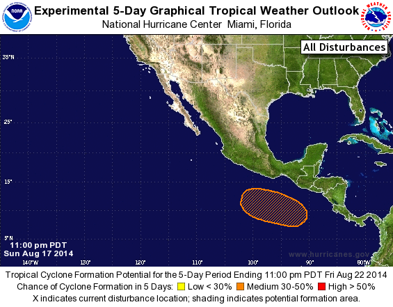
TROPICAL WEATHER OUTLOOK
NWS NATIONAL HURRICANE CENTER MIAMI FL
1100 PM PDT SUN AUG 17 2014

For the eastern North Pacific...east of 140 degrees west longitude:

The National Hurricane Center is issuing advisories on Tropical
Storm Karina, located more than a thousand miles east of the Big
Island of Hawaii, and on newly formed Tropical Depression Twelve-E,
located several hundred miles southwest of the southern tip of the
Baja California peninsula.

1. An area of low pressure is expected to form in a few days to the
south of the Gulf of Tehuantepec.  Slow development of this system
is possible later this week while the low moves roughly parallel to
the coast of southwestern Mexico.
* Formation chance through 48 hours...low...near 0 percent.
* Formation chance through 5 days...medium...40 percent.

Public Advisories on Tropical Depression Twelve-E are issued under
WMO header WTPZ32 KNHC and under AWIPS header MIATCPEP2.
Forecast/Advisories are issued under WMO header WTPZ22 KNHC and
under AWIPS header MIATCMEP2.

Forecaster Cangialosi
List of Atlantic Outlooks (May 2023 - present)
List of East Pacific Outlooks (May 2023 - present)
List of Central Pacific Outlooks (May 2023 - present)
List of Atlantic Outlooks (July 2014 - April 2023)
List of East Pacific Outlooks (July 2014 - April 2023)
List of Central Pacific Outlooks (June 2019 - April 2023)
List of Atlantic Outlooks (June 2009 - June 2014)
List of East Pacific Outlooks (June 2009 - June 2014)