


NHC Graphical Outlook Archive
|
« Earliest Available ‹ Earlier Later › Latest Available » |
| Eastern Pacific | Atlantic |
|
|
(mouse over shaded areas for details; click on shaded areas or disturbance numbers to switch views) |
Tropical Weather Outlook Text
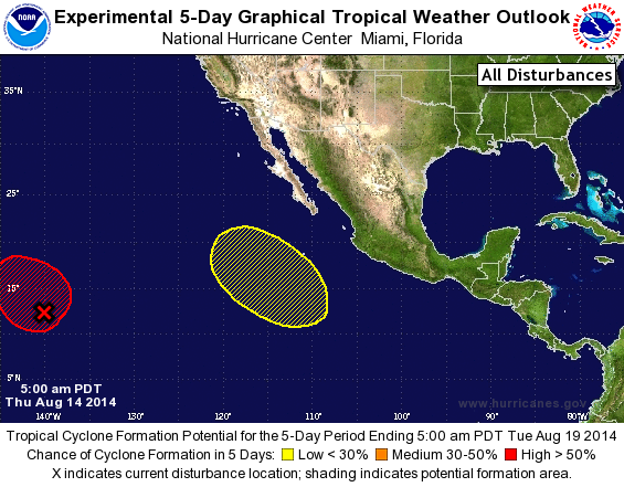
TROPICAL WEATHER OUTLOOK
NWS NATIONAL HURRICANE CENTER MIAMI FL
500 AM PDT THU AUG 14 2014

For the eastern North Pacific...east of 140 degrees west longitude:

The National Hurricane Center is issuing advisories on Tropical
Storm Karina, located several hundred miles southwest of the
southern tip of the Baja California peninsula.

1. Satellite-derived wind data indicate that the area of low pressure
located about 1150 miles east-southeast of the Big Island of Hawaii
has become better defined overnight.  Although shower and
thunderstorm activity has changed little during the past several
hours, gradual development of this disturbance is expected during
the next few days and a tropical depression could form by late
Friday or Saturday. This system is moving slowly west-northwestward
and is currently crossing 140W longitude, and it will move into
the central Pacific basin later this morning. The future discussions
on this disturbance will be provided in Tropical Weather Outlooks
issued by the Central Pacific Hurricane Center in Honolulu, Hawaii.
* Formation chance through 48 hours...high...60 percent.
* Formation chance through 5 days...high...80 percent.

2. An area of low pressure is forecast to form well south-southwest of
the southern tip of the Baja California peninsula in a couple of
days.  Some gradual development of this system is possible this
weekend and early next week while the system moves generally
northwestward.
* Formation chance through 48 hours...low...near 0 percent.
* Formation chance through 5 day...low...20 percent.

Tropical Weather Outlooks issued by the Central Pacific Hurricane
Center can be found under WMO header ACPN50 PHFO and under AWIPS
header HFOTWOCP.

Forecaster Stewart
List of Atlantic Outlooks (May 2023 - present)
List of East Pacific Outlooks (May 2023 - present)
List of Central Pacific Outlooks (May 2023 - present)
List of Atlantic Outlooks (July 2014 - April 2023)
List of East Pacific Outlooks (July 2014 - April 2023)
List of Central Pacific Outlooks (June 2019 - April 2023)
List of Atlantic Outlooks (June 2009 - June 2014)
List of East Pacific Outlooks (June 2009 - June 2014)