


NHC Graphical Outlook Archive
|
« Earliest Available ‹ Earlier Later › Latest Available » |
| Eastern Pacific | Atlantic |
|
|
(mouse over shaded areas for details; click on shaded areas or disturbance numbers to switch views) |
Tropical Weather Outlook Text
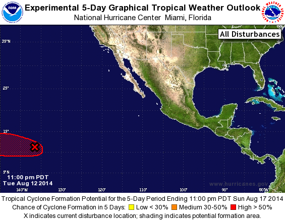
TROPICAL WEATHER OUTLOOK
NWS NATIONAL HURRICANE CENTER MIAMI FL
1100 PM PDT TUE AUG 12 2014

For the eastern North Pacific...east of 140 degrees west longitude:

The National Hurricane Center is issuing advisories on newly formed
Tropical Depression Eleven-E, located a few hundred miles
west-southwest of Manzanillo, Mexico.

1. An elongated area of low pressure centered about 1400 miles
east-southeast of the Big Island of Hawaii is producing disorganized
showers and thunderstorms.  Environmental conditions are expected to
become more conducive for development in a couple of days when the
system enters the Central Pacific Hurricane Center's area of
responsibility.
* Formation chance through 48 hours...low...20 percent.
* Formation chance through 5 days...high...60 percent.

Public Advisories on Tropical Depression Eleven-E are issued under
WMO header WTPZ31 KNHC and under AWIPS header MIATCPEP1.
Forecast/Advisories are issued under WMO header WTPZ21 KNHC and
under AWIPS header MIATCMEP1.

Forecaster Cangialosi
List of Atlantic Outlooks (May 2023 - present)
List of East Pacific Outlooks (May 2023 - present)
List of Central Pacific Outlooks (May 2023 - present)
List of Atlantic Outlooks (July 2014 - April 2023)
List of East Pacific Outlooks (July 2014 - April 2023)
List of Central Pacific Outlooks (June 2019 - April 2023)
List of Atlantic Outlooks (June 2009 - June 2014)
List of East Pacific Outlooks (June 2009 - June 2014)