


NHC Graphical Outlook Archive
|
« Earliest Available ‹ Earlier Later › Latest Available » |
| Eastern Pacific | Atlantic |
|
|
(mouse over shaded areas for details; click on shaded areas or disturbance numbers to switch views) |
Tropical Weather Outlook Text
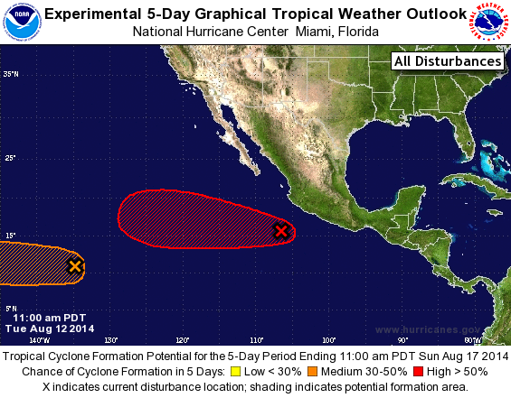
TROPICAL WEATHER OUTLOOK
NWS NATIONAL HURRICANE CENTER MIAMI FL
1100 AM PDT TUE AUG 12 2014

For the eastern North Pacific...east of 140 degrees west longitude:

1. Showers and thunderstorms associated with an area of low pressure
located a few hundred miles south-southwest of Manzanillo, Mexico
have become a little better organized.  Environmental conditions
are expected to be conducive for development, and a tropical
depression could form tonight or on Wednesday while the system moves
westward at 10 to 15 mph.
* Formation chance through 48 hours...high...60 percent.
* Formation chance through 5 days...high...90 percent.

2. A broad but disorganized area of disturbed weather is centered
about 1500 miles east-southeast of the Big Island of Hawaii.
Environmental conditions are expected to become more conducive for
development in a couple of days when the system enters the Central
Pacific Hurricane Center's area of responsibility.
* Formation chance through 48 hours...low...10 percent.
* Formation chance through 5 days...medium...40 percent.

Forecaster Cangialosi
List of Atlantic Outlooks (May 2023 - present)
List of East Pacific Outlooks (May 2023 - present)
List of Central Pacific Outlooks (May 2023 - present)
List of Atlantic Outlooks (July 2014 - April 2023)
List of East Pacific Outlooks (July 2014 - April 2023)
List of Central Pacific Outlooks (June 2019 - April 2023)
List of Atlantic Outlooks (June 2009 - June 2014)
List of East Pacific Outlooks (June 2009 - June 2014)