


NHC Graphical Outlook Archive
|
« Earliest Available ‹ Earlier Later › Latest Available » |
| Eastern Pacific | Atlantic |
|
|
(mouse over shaded areas for details; click on shaded areas or disturbance numbers to switch views) |
Tropical Weather Outlook Text
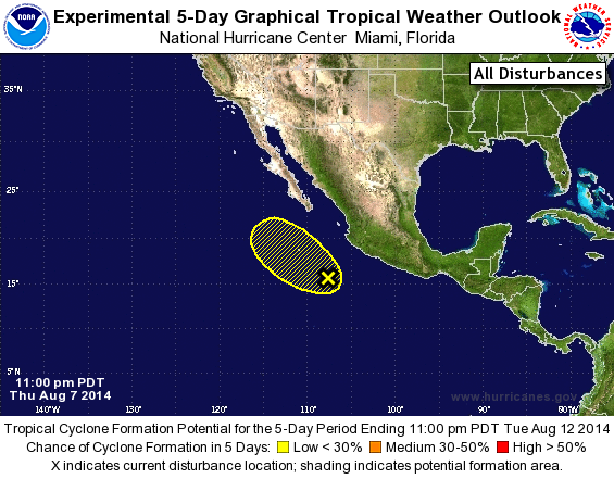
TROPICAL WEATHER OUTLOOK
NWS NATIONAL HURRICANE CENTER MIAMI FL
1100 PM PDT THU AUG 7 2014

For the eastern North Pacific...east of 140 degrees west longitude:

The National Hurricane Center has issued its last advisory on
Hurricane Julio located about a thousand miles east of Hilo,
Hawaii.  Future advisories will be issued by the Central Pacific
Hurricane Center in Honolulu, Hawaii.

1. A trough of low pressure located several hundred miles south-
southeast of the southern tip of the Baja California peninsula
continues to produce disorganized showers and thunderstorms.
Development, if any, of this system is expected to be slow to occur
while it moves northwestward at 10 to 15 mph.
* Formation chance through 48 hours...low...10 percent.
* Formation chance through 5 days...low...20 percent.

Future Public advisories on Julio will be issued by the Central
Pacific Hurricane Center under AWIPS header HFOTCPCP4 and WMO
header WTPA34 PHFO.  Forecast/Advisories on Julio will be issued
under AWIPS header HFOTCMCP4 and WMO header WTPA24 PHFO.

Forecaster Blake
List of Atlantic Outlooks (May 2023 - present)
List of East Pacific Outlooks (May 2023 - present)
List of Central Pacific Outlooks (May 2023 - present)
List of Atlantic Outlooks (July 2014 - April 2023)
List of East Pacific Outlooks (July 2014 - April 2023)
List of Central Pacific Outlooks (June 2019 - April 2023)
List of Atlantic Outlooks (June 2009 - June 2014)
List of East Pacific Outlooks (June 2009 - June 2014)