


NHC Graphical Outlook Archive
|
« Earliest Available ‹ Earlier Later › Latest Available » |
| Eastern Pacific | Atlantic |
|
|
(mouse over shaded areas for details; click on shaded areas or disturbance numbers to switch views) |
Tropical Weather Outlook Text
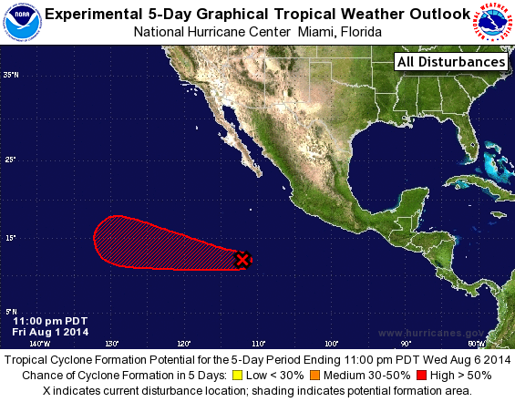
TROPICAL WEATHER OUTLOOK
NWS NATIONAL HURRICANE CENTER MIAMI FL
1100 PM PDT FRI AUG 1 2014

For the eastern North Pacific...east of 140 degrees west longitude:

The National Hurricane Center is issuing advisories on Hurricane
Iselle, located more than a thousand miles west-southwest of the
southern tip of the Baja California peninsula.

A weak low pressure area located about 1100 miles east-southeast of
the Big Island of Hawaii has moved into the central Pacific basin.
Please see the Tropical Weather Outlook from the Central Pacific
Hurricane Center for more details.

1. Showers and thunderstorms associated with an area of low pressure
located about 700 miles southwest of Manzanillo, Mexico, are
gradually becoming better organized.  Environmental conditions are
conducive for development, and this system is likely to become a
tropical depression over the weekend as it moves westward at about
10 mph.
* Formation chance through 48 hours...high...60 percent.
* Formation chance through 5 days...high...90 percent.

The central Pacific Tropical Weather Outlook can be found under
AWIPS header HFOTWOEP and WMO header ACPN50 PHFO.

Forecaster Blake
List of Atlantic Outlooks (May 2023 - present)
List of East Pacific Outlooks (May 2023 - present)
List of Central Pacific Outlooks (May 2023 - present)
List of Atlantic Outlooks (July 2014 - April 2023)
List of East Pacific Outlooks (July 2014 - April 2023)
List of Central Pacific Outlooks (June 2019 - April 2023)
List of Atlantic Outlooks (June 2009 - June 2014)
List of East Pacific Outlooks (June 2009 - June 2014)