


NHC Graphical Outlook Archive
|
« Earliest Available ‹ Earlier Later › Latest Available » |
| Eastern Pacific | Atlantic |
|
|
(mouse over shaded areas for details; click on shaded areas or disturbance numbers to switch views) |
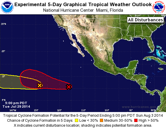
Tropical Weather Outlook Text
TROPICAL WEATHER OUTLOOK
NWS NATIONAL HURRICANE CENTER MIAMI FL
500 PM PDT TUE JUL 29 2014

For the eastern North Pacific...east of 140 degrees west longitude:

1. An area of low pressure located about 900 miles south-southwest
of the southern tip of the Baja California peninsula is producing
disorganized cloudiness and thunderstorms.  Environmental conditions
are conducive for gradual development of this system during the next
several days as this system moves west-northwestward at 10 to 15
mph.
* Formation chance through 48 hours...low...near 10 percent.
* Formation chance through 5 days...high...60 percent.

2. An area of cloudiness and thunderstorms has formed in association
with a low pressure system about 1500 miles southwest of the
southern tip of the Baja California peninsula.  Environmental
conditions appear favorable for some slow development of this system
during the next several days as the low moves generally westward.
* Formation chance through 48 hours...low...near 10 percent.
* Formation chance through 5 days...low...20 percent.

Forecaster Kimberlain
List of Atlantic Outlooks (May 2023 - present)
List of East Pacific Outlooks (May 2023 - present)
List of Central Pacific Outlooks (May 2023 - present)
List of Atlantic Outlooks (July 2014 - April 2023)
List of East Pacific Outlooks (July 2014 - April 2023)
List of Central Pacific Outlooks (June 2019 - April 2023)
List of Atlantic Outlooks (June 2009 - June 2014)
List of East Pacific Outlooks (June 2009 - June 2014)