


NHC Graphical Outlook Archive
|
« Earliest Available ‹ Earlier Later › Latest Available » |
| Eastern Pacific | Atlantic |
|
|
(mouse over shaded areas for details; click on shaded areas or disturbance numbers to switch views) |
Tropical Weather Outlook Text
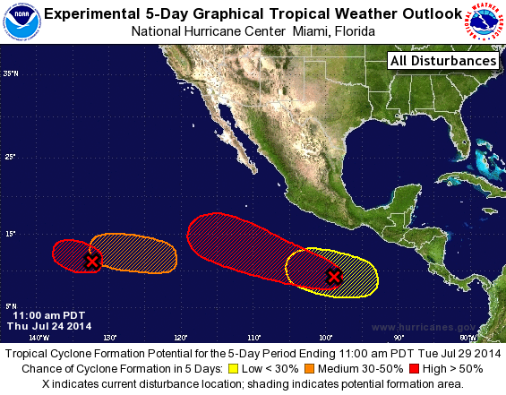
TROPICAL WEATHER OUTLOOK
NWS NATIONAL HURRICANE CENTER MIAMI FL
1100 AM PDT THU JUL 24 2014

For the eastern North Pacific...east of 140 degrees west longitude:

1. A low pressure area located about 1600 miles southwest of the
southern tip of the Baja California peninsula has changed little
this morning and the associated thunderstorm activity is currently
not well organized.  However, environmental conditions still appear
conducive for development, and this system is expected to become a
tropical depression during the next day or two while it moves
westward or west-northwestward at about 10 mph. Upper-level winds
are forecast to limit the development chances by the weekend.
* Formation chance through 48 hours...high...70 percent.
* Formation chance through 5 days...high...70 percent.

2. A large area of disorganized showers and thunderstorms continues
well south of the coast of southeastern Mexico.  Upper-level winds
are expected to become more favorable for development of this system
over the next few days while it moves west-northwestward at 10 to 15
mph.
* Formation chance through 48 hours...low...20 percent.
* Formation chance through 5 days...high...60 percent.

3. Another area of low pressure is expected to form during the next
couple of days roughly 1000 miles southwest of the southern tip of
the Baja California peninsula.  Some development of this system is
possible by the weekend while it moves to the west or
west-northwest at 10 to 15 mph.
* Formation chance through 48 hours...low...near 0 percent.
* Formation chance through 5 days...medium...40 percent.

4. Yet another area of low pressure could form well south of
southeastern Mexico by early next week.  Some gradual development
of this system is possible after that time.
* Formation chance through 48 hours...low...near 0 percent.
* Formation chance through 5 days...low...near 20 percent.

Forecaster Blake
List of Atlantic Outlooks (May 2023 - present)
List of East Pacific Outlooks (May 2023 - present)
List of Central Pacific Outlooks (May 2023 - present)
List of Atlantic Outlooks (July 2014 - April 2023)
List of East Pacific Outlooks (July 2014 - April 2023)
List of Central Pacific Outlooks (June 2019 - April 2023)
List of Atlantic Outlooks (June 2009 - June 2014)
List of East Pacific Outlooks (June 2009 - June 2014)