


NHC Graphical Outlook Archive
|
« Earliest Available ‹ Earlier Later › Latest Available » |
| Eastern Pacific | Atlantic |
|
|
(mouse over shaded areas for details; click on shaded areas or disturbance numbers to switch views) |
Tropical Weather Outlook Text
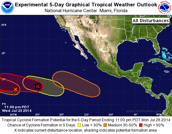
TROPICAL WEATHER OUTLOOK
NWS NATIONAL HURRICANE CENTER MIAMI FL
1100 PM PDT WED JUL 23 2014

For the eastern North Pacific...east of 140 degrees west longitude:

1. A low pressure system located about 1450 miles west-southwest of
the southern tip of the Baja California peninsula continues to
gradually show signs of organization.  Environmental conditions
appear conducive for additional development, and this system is
expected to become a tropical depression during the next day or two
while it moves westward or west-northwestward at about 10 mph.
* Formation chance through 48 hours...high...80 percent.
* Formation chance through 5 days...high...90 percent.

2. A surface trough of low pressure located about 1250 miles east-
southeast of the Big Island of Hawaii is producing disorganized
shower activity.  Development of this system is possible during
the next few days while it moves west-northwestward at 10 to 15
mph into the central Pacific.
* Formation chance through 48 hours...medium...30 percent.
* Formation chance through 5 days...medium...50 percent.

3. An area of low pressure is forecast to form several hundred miles
south-southwest of the coast of Mexico in a few days.  Some
development of this system is expected over the weekend while it
moves generally west-northwestward at 10 to 15 mph.
* Formation chance through 48 hours...low...near 0 percent.
* Formation chance through 5 days...medium...50 percent.

4. Another area of low pressure could form during the next couple of
days about 1000 miles southwest of the southern tip of the Baja
California peninsula.  Some gradual development of this system
is possible by the weekend while it moves generally
west-northwestward at 10 to 15 mph.
* Formation chance through 48 hours...low...near 0 percent.
* Formation chance through 5 days...low...20 percent.

Forecaster Berg
List of Atlantic Outlooks (May 2023 - present)
List of East Pacific Outlooks (May 2023 - present)
List of Central Pacific Outlooks (May 2023 - present)
List of Atlantic Outlooks (July 2014 - April 2023)
List of East Pacific Outlooks (July 2014 - April 2023)
List of Central Pacific Outlooks (June 2019 - April 2023)
List of Atlantic Outlooks (June 2009 - June 2014)
List of East Pacific Outlooks (June 2009 - June 2014)