


NHC Graphical Outlook Archive
|
« Earliest Available ‹ Earlier Later › Latest Available » |
| Eastern Pacific | Atlantic |
|
|
(mouse over shaded areas for details; click on shaded areas or disturbance numbers to switch views) |
Tropical Weather Outlook Text
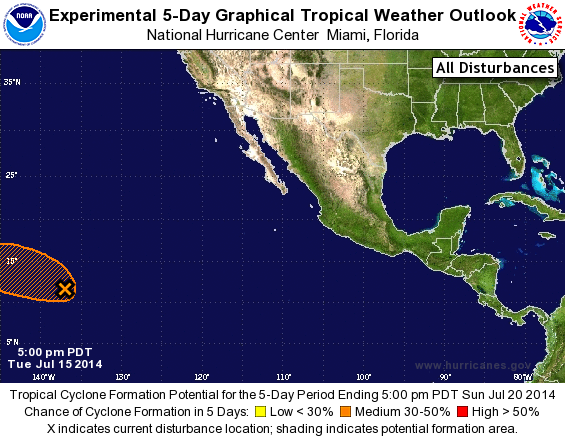
TROPICAL WEATHER OUTLOOK
NWS NATIONAL HURRICANE CENTER MIAMI FL
500 PM PDT TUE JUL 15 2014

For the eastern North Pacific...east of 140 degrees west longitude:

1. Shower activity associated with an area of low pressure located
about 1300 miles east-southeast of the Big Island of Hawaii remains
disorganized.  Environmental conditions are forecast to be conducive
for some gradual development of this system during the next couple
of days.  After that time upper-level winds are expected to become
unfavorable for development.  The low is forecast to move toward the
west or west-northwest at 10 to 15 mph and move into the central
Pacific Basin by late Wednesday.
* Formation chance through 48 hours...medium...30 percent.
* Formation chance through 5 days...medium...40 percent.

Forecaster Brown
List of Atlantic Outlooks (May 2023 - present)
List of East Pacific Outlooks (May 2023 - present)
List of Central Pacific Outlooks (May 2023 - present)
List of Atlantic Outlooks (July 2014 - April 2023)
List of East Pacific Outlooks (July 2014 - April 2023)
List of Central Pacific Outlooks (June 2019 - April 2023)
List of Atlantic Outlooks (June 2009 - June 2014)
List of East Pacific Outlooks (June 2009 - June 2014)