ZCZC MIATWOAT ALL
TTAA00 KNHC DDHHMM
Tropical Weather Outlook
NWS National Hurricane Center Miami FL
100 PM EST Sun Nov 6 2022
For the North Atlantic...Caribbean Sea and the Gulf of Mexico:
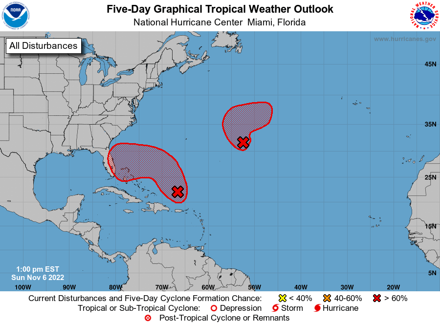
1. Southwestern Atlantic:
An area of low pressure located more than 200 miles north of Puerto
Rico is producing a large area of disorganized showers and
thunderstorms. This system is forecast to move northward and then
northwestward into the southwestern Atlantic where environmental
conditions appear conducive for additional development, and a
subtropical or tropical storm is likely to form in the next day or
so. The system is then forecast to turn westward or
west-southwestward over the southwestern Atlantic by the middle part
of this week where additional development is possible.
Regardless of development, there is an increasing risk of coastal
flooding, tropical-storm-force winds, heavy rainfall, rough surf,
and beach erosion along much of the southeastern United States
coast, the Florida east coast, and portions of the central and
northwestern Bahamas beginning in the early to middle part of this
week. Interests in those areas should continue to monitor the
progress of this system as tropical storm, hurricane, and storm
surge watches could be required for a portion of these areas by
early Monday. Additional information on this system, including gale
warnings, can be found in High Seas Forecasts issued by the National
Weather Service and in products from your local weather office.
* Formation chance through 48 hours...high...80 percent.
* Formation chance through 5 days...high...90 percent.
2. Central Subtropical Atlantic:
A well-defined area of low pressure located several hundred miles
east of Bermuda continues to produce gale-force winds and an area of
showers and thunderstorms displaced northeast of the center. If the
associated shower activity redevelops closer to the center, a
tropical storm could form over the next couple of days while the
system drifts slowly initially but then begins to move northeastward
over the central Atlantic. The system is then forecast to merge with
a strong cold front by the middle part of this week. Additional
information on this system, including gale warnings, can be found in
High Seas Forecasts issued by the National Weather Service.
* Formation chance through 48 hours...high...70 percent.
* Formation chance through 5 days...high...70 percent.
High Seas Forecasts issued by the National Weather Service
can be found under AWIPS header NFDHSFAT1, WMO header FZNT01
KWBC, and online at ocean.weather.gov/shtml/NFDHSFAT1.php
Forecaster Papin