ZCZC MIATWOAT ALL
TTAA00 KNHC DDHHMM
Tropical Weather Outlook
NWS National Hurricane Center Miami FL
200 AM EDT Sat Nov 5 2022
For the North Atlantic...Caribbean Sea and the Gulf of Mexico:
Active Systems:
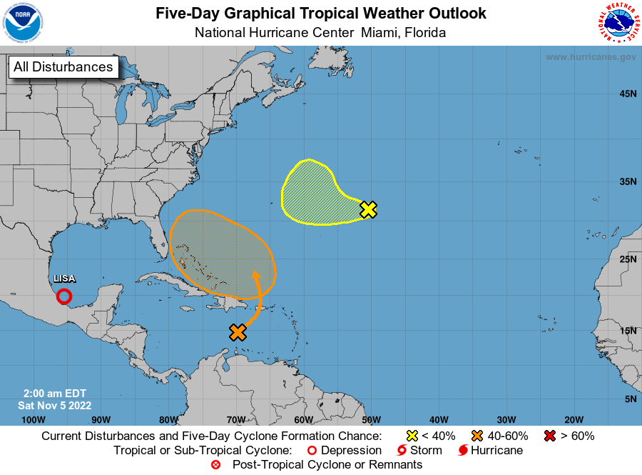
The National Hurricane Center is issuing advisories on Tropical
Depression Lisa, located over the southwestern Gulf of Mexico.
1. Central Subtropical Atlantic:
A broad area of showers and a few thunderstorms located several
hundred miles east of Bermuda is associated with an non-tropical
area of low pressure. Recent satellite wind data shows that the
circulation has become somewhat better defined, and addition slow
tropical or subtropical development of this disturbance is possible
during the next two to three days. After that time, the system is
forecast to encounter stronger upper-level winds and further
development is not anticipated.
* Formation chance through 48 hours...low...20 percent.
* Formation chance through 5 days...low...30 percent.
2. Southwestern Atlantic:
A large non-tropical low pressure system is expected to develop
across the northeastern Caribbean Sea and southwestern Atlantic by
the latter part of the weekend. The system is initially expected to
be very broad and disorganized. However, it could begin to acquire
subtropical or tropical characteristics during the early part of
next week, and a subtropical or tropical depression could form
during the early to middle portion of next week while the system
moves generally westward to west-northwestward over the southwestern
Atlantic. Regardless of development, there is an increasing risk of
coastal flooding, gale-force winds, heavy rainfall, rough surf, and
beach erosion along much of the southeastern United States coast,
the Florida east coast, and portions of the central and northwestern
Bahamas during the early to middle part of next week.
* Formation chance through 48 hours...low...10 percent.
* Formation chance through 5 days...medium...60 percent.
Forecaster Beven