ZCZC MIATWOAT ALL
TTAA00 KNHC DDHHMM
Special Tropical Weather Outlook
NWS National Hurricane Center Miami FL
1025 AM EDT Mon Oct 24 2022
For the North Atlantic...Caribbean Sea and the Gulf of Mexico:
Special outlook issued to update discussion of the disturbance in
the Subtropical Atlantic.
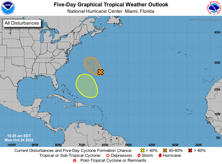
1. Central Subtropical Atlantic:
Updated: Satellite imagery and Bermuda radar data indicate that the
shower and thunderstorm activity associated with an area of low
pressure located about 150 miles east-southeast of Bermuda has
become more concentrated during the past few hours and a small
surface circulation appears to be forming. Although environmental
conditions are only marginally conducive, a tropical or subtropical
cyclone could develop while it passes near Bermuda later today and
tonight. Afterward, the system is forecast to turn northward toward
cooler waters and less favorable upper-level winds over the
northwestern Atlantic, and further development is not anticipated by
that time. Regardless of development, periods of locally heavy
rainfall and gusty winds are expected over Bermuda through tonight.
Interests in Bermuda should monitor the progress of this system.
* Formation chance through 48 hours...medium...40 percent.
* Formation chance through 5 days...medium...40 percent.
2. Southwestern Atlantic:
An area of low pressure is expected to form north of Puerto
Rico over the southwestern Atlantic in a few days. Thereafter,
environmental conditions appear conducive for some subtropical
development of this system while it meanders over the southwestern
Atlantic through the early part of the weekend.
* Formation chance through 48 hours...low...near 0 percent.
* Formation chance through 5 days...low...20 percent.
Forecaster Roberts