ZCZC MIATWOAT ALL
TTAA00 KNHC DDHHMM
Tropical Weather Outlook
NWS National Hurricane Center Miami FL
200 AM EDT Wed Oct 5 2022
For the North Atlantic...Caribbean Sea and the Gulf of Mexico:
Active Systems:
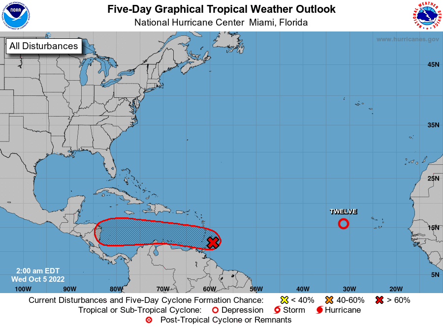
The National Hurricane Center is issuing advisories on Tropical
Depression Twelve, located a few hundred miles west of the Cabo
Verde Islands.
East of the Windward Islands:
A broad area of low pressure located just east of the Windward
Islands continues to produce a large area of showers and
thunderstorms. Satellite-derived wind data and radar images from
Barbados indicate that this system does not yet have a well-defined
circulation center. However, upper-level winds are forecast to
become more conducive for development, and a tropical depression is
likely to form over the next several days if the system remains over
open waters while moving generally westward at about 15 mph through
the Windward Islands and into the Caribbean Sea. An Air Force
reconnaissance mission is scheduled to investigate the system this
morning, if necessary.
1. Regardless of development, heavy rainfall with localized flooding,
as well as gusty winds to gale force, are expected over portions of
the Windward Islands, northern portions of South America, and the
ABC Islands during the next couple of days. Interests in those
locations, in addition to those in Central America, should continue
to monitor the progress of this system.
* Formation chance through 48 hours...medium...60 percent.
* Formation chance through 5 days...high...80 percent.
Key messages for the disturbance east of the Windward Islands can be
found on the National Hurricane Center website at www.hurricanes.gov
Public Advisories on Tropical Depression Twelve are issued under
WMO header WTNT32 KNHC and under AWIPS header MIATCPAT2.
Forecast/Advisories on Tropical Depression Twelve are issued under
WMO header WTNT22 KNHC and under AWIPS header MIATCMAT2.
Forecaster Pasch