ZCZC MIATWOAT ALL
TTAA00 KNHC DDHHMM
Tropical Weather Outlook
NWS National Hurricane Center Miami FL
Issued by the NWS Weather Prediction Center College Park MD
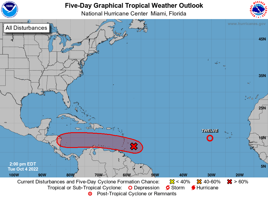
200 PM EDT Tue Oct 4 2022
For the North Atlantic...Caribbean Sea and the Gulf of Mexico:
1. Eastern Tropical Atlantic:
Satellite images indicate that the circulation associated with an
area of low pressure located a few hundred miles west-southwest of
the Cabo Verde Islands is becoming better defined, and the
associated shower and thunderstorm activity has become more
concentrated near the low's center. A short-lived tropical
depression is likely to form later today or tonight before
upper-level winds increase and become too hostile for further
development on Wednesday. The low is forecast to move
northwestward at about 10 mph over the eastern tropical Atlantic
during the next couple of days.
* Formation chance through 48 hours...high...80 percent.
* Formation chance through 5 days...high...80 percent.
2. East of the Windward Islands:
A broad area of low pressure located a couple of hundred miles east
of the southern Windward Islands is producing an area of showers
and thunderstorms to the southeast of an ill-defined center.
Upper-level winds are likely to become more conducive for
development, and a tropical depression could form during the next
couple of days, if the system stays far enough away from land while
moving westward at about 15 mph across the Windward Islands and
southeastern Caribbean Sea. Conditions appear to become more
conducive for development later this week when the system reaches
the central and western Caribbean Sea. Regardless of development,
locally heavy rainfall and gusty winds are expected over portions
of the Windward Islands tonight and Wednesday. Interests in the
Windward Islands, the ABC Islands, and the northern coast of
Venezuela should monitor the progress of this system. An Air Force
Reserve Hurricane Hunter aircraft is currently investigating this
system.
* Formation chance through 48 hours...medium...40 percent.
* Formation chance through 5 days...high...70 percent.
Forecaster Bann