ZCZC MIATWOAT ALL
TTAA00 KNHC DDHHMM
Special Tropical Weather Outlook
NWS National Hurricane Center Miami FL
1150 AM EDT Tue Oct 4 2022
Special Tropical Weather Outlook to update discussion of the
tropical wave east of the Windward Islands
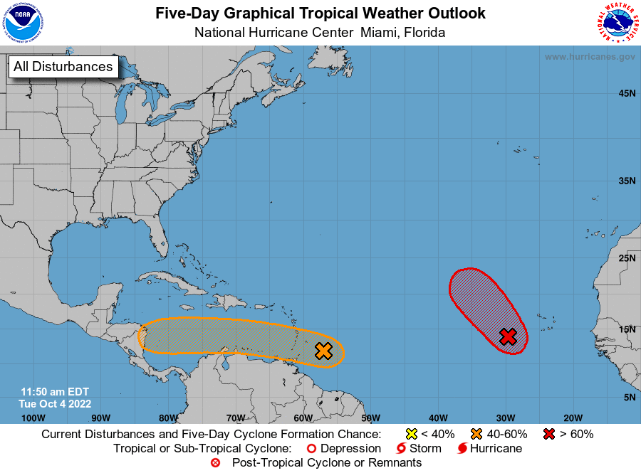
For the North Atlantic...Caribbean Sea and the Gulf of Mexico:
1. Eastern Tropical Atlantic:
A broad low pressure system located a few hundred miles
west-southwest of the Cabo Verde Islands continues to produce a
large area of showers and thunderstorms. Environmental conditions
are currently conducive for development, and a tropical depression
is likely to form during the next day or so while moving
northwestward at about 10 mph over the eastern tropical Atlantic.
Upper-level winds are expected to become less conducive for
development by Wednesday and Thursday.
* Formation chance through 48 hours...high...80 percent.
* Formation chance through 5 days...high...80 percent.
2. East of the Windward Islands:
Updated: Visible satellite images and recent satellite-derived
wind data suggest that a broad low-level circulation could be
forming in association with the tropical wave located a few hundred
miles east of the southern Windward Islands. Although the wave
is currently being affected by strong upper-level winds, conditions
could become more conducive for a tropical depression to form while
moving westward at about 15 mph, crossing the Windward Islands
tonight and early Wednesday. Conditions appear to become more
conducive for development later this week when the system reaches
the central and western Caribbean Sea. Regardless of development,
locally heavy rainfall and gusty winds are expected over portions of
the Windward Islands tonight and Wednesday. Interests in the
Windward Islands, the ABC Islands, and the northern coast of
Venezuela should monitor the progress of this system. An Air Force
Reserve Hurricane Hunter aircraft is currently enroute to
investigate this system.
* Formation chance through 48 hours...medium...40 percent.
* Formation chance through 5 days...medium...60 percent.
Forecaster Berg