ZCZC MIATWOAT ALL
TTAA00 KNHC DDHHMM
Tropical Weather Outlook
NWS National Hurricane Center Miami FL
800 AM EDT Tue Oct 4 2022
For the North Atlantic...Caribbean Sea and the Gulf of Mexico:
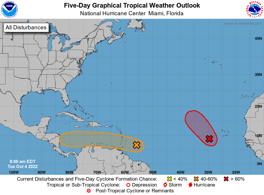
1. Eastern Tropical Atlantic:
A broad low pressure system located a few hundred miles
west-southwest of the Cabo Verde Islands continues to produce a
large area of showers and thunderstorms. Environmental conditions
are currently conducive for development, and a tropical depression
is likely to form during the next day or so while moving
northwestward at about 10 mph over the eastern tropical Atlantic.
Upper-level winds are expected to become less conducive for
development by Wednesday and Thursday.
* Formation chance through 48 hours...high...80 percent.
* Formation chance through 5 days...high...80 percent.
2. East of the Windward Islands:
Showers and thunderstorms associated with a tropical wave located a
few hundred miles east of the southern Windward Islands have
increased a little this morning, but there are not yet any signs of
significant organization. The wave is forecast to move westward at
about 15 mph, crossing the Windward Islands tonight and early
Wednesday. Some slow development is possible while the wave
continues westward, and a tropical depression could form by late
this week or this weekend over the central or western Caribbean Sea.
Interests in the Windward Islands, the ABC Islands, and the
northern coast of Venezuela should monitor the progress of this
system. An Air Force Reserve Hurricane Hunter aircraft is
scheduled to investigate this system this afternoon, if necessary.
* Formation chance through 48 hours...low...20 percent.
* Formation chance through 5 days...medium...40 percent.
Forecaster Berg