ZCZC MIATWOAT ALL
TTAA00 KNHC DDHHMM
Tropical Weather Outlook
NWS National Hurricane Center Miami FL
800 PM EDT Thu Sep 22 2022
For the North Atlantic...Caribbean Sea and the Gulf of Mexico:
Active Systems:
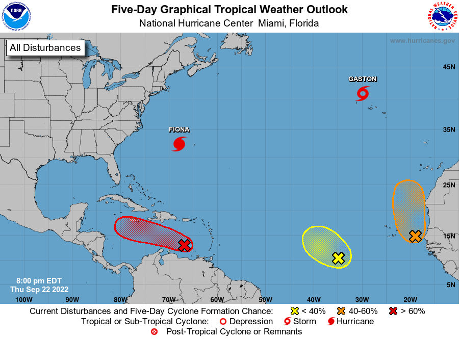
The National Hurricane Center is issuing advisories on Hurricane
Fiona, located a few hundred miles west-southwest of Bermuda,
and on Tropical Storm Gaston, located a couple of hundred miles
northwest of the central Azores.
1. Southeastern Caribbean Sea:
Showers and thunderstorms remain disorganized in association with a
low pressure system located over the southeastern Caribbean Sea
about 150 miles east-northeast of Curacao. The upper-level wind
environment over the low is expected to become more conducive for
development, and a tropical depression is expected to form during
the next day or two while moving west-northwestward at 10 to 15 mph
across the central Caribbean Sea. Locally heavy rainfall and gusty
winds are likely to affect northwestern Venezuela, the ABC island
chain, and northeastern Colombia through Friday. Interests in
Jamaica and the Cayman Islands should closely monitor the progress
of this system.
* Formation chance through 48 hours...high...90 percent.
* Formation chance through 5 days...high...90 percent.
2. Eastern Tropical Atlantic:
A broad area of low pressure, associated with a tropical wave and
located about 100 miles west of Dakar, Senegal, is producing a
disorganized area of showers and thunderstorms off the coasts of
Senegal and Mauritania. Although the system is pulling in nearby
dry air, environmental conditions are forecast to otherwise be
conducive for some development, and a tropical depression could form
by this weekend while the system moves northward at about 10 mph,
parallel to the coast of west Africa.
* Formation chance through 48 hours...medium...60 percent.
* Formation chance through 5 days...medium...60 percent.
3. Central Tropical Atlantic:
Shower and thunderstorm activity has decreased since earlier today
in association with a broad area of low pressure located several
hundred miles west-southwest of the Cabo Verde Islands. Despite
marginal environmental conditions, some slow development of this
system is possible over the next several days while it drifts
northwestward or northward over the central tropical Atlantic.
* Formation chance through 48 hours...low...20 percent.
* Formation chance through 5 days...low...30 percent.
Forecaster Berg