ZCZC MIATWOAT ALL
TTAA00 KNHC DDHHMM
Tropical Weather Outlook
NWS National Hurricane Center Miami FL
800 PM EDT Wed Sep 21 2022
For the North Atlantic...Caribbean Sea and the Gulf of Mexico:
Active Systems:
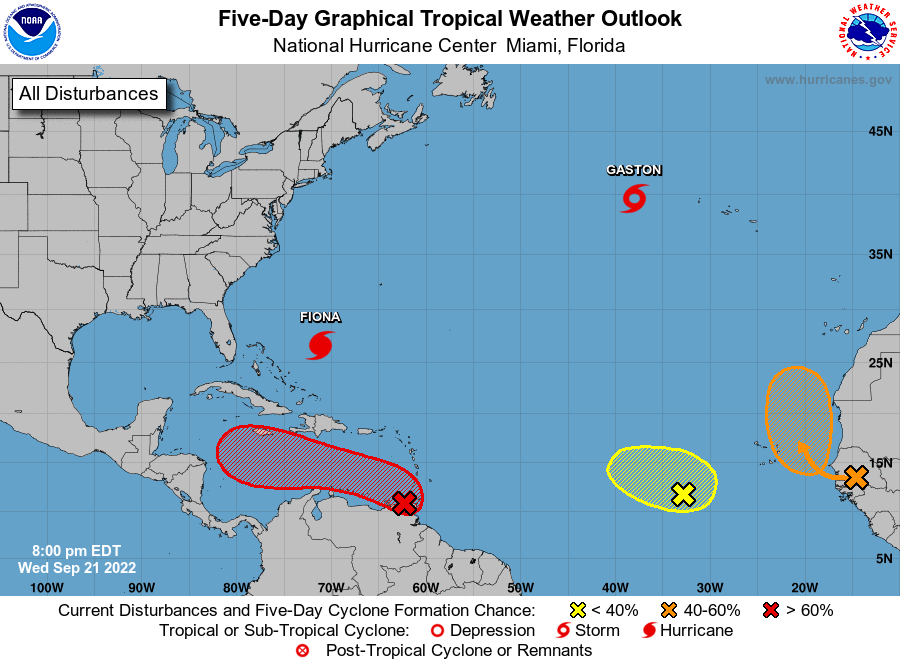
The National Hurricane Center is issuing advisories on Hurricane
Fiona, located several hundred miles southwest of Bermuda, and on
Tropical Storm Gaston, located several hundred miles west of the
Azores.
1. Southeastern Caribbean Sea:
Showers and thunderstorms associated with a tropical wave located
over the far southeastern Caribbean Sea have changed little in
organization since this morning. Environmental conditions are
forecast to become more conducive for development, and a tropical
depression is likely to form within the next couple of days. The
disturbance is forecast to move west-northwestward across the
eastern Caribbean Sea during the next day or two, and be over the
central Caribbean Sea this weekend. Regardless of development,
locally heavy rainfall and gusty winds are likely to affect the
Windward Islands tonight, and northern Venezuela, northeastern
Colombia, and the ABC island chain during the next couple of days.
An Air Force Reserve reconnaissance aircraft is currently surveying
the system, and data from this mission will be assimilated into
tonight's forecast models.
* Formation chance through 48 hours...high...70 percent.
* Formation chance through 5 days...high...90 percent.
2. Eastern Tropical Atlantic:
Showers and thunderstorms located near the west coast of Africa are
associated with a tropical wave that is forecast to move over the
far eastern Atlantic waters on Thursday. Thereafter, environmental
conditions are forecast to be conducive for some development, and a
tropical depression could form by this weekend while the system
moves slowly northward, between west Africa and the Cabo Verde
Islands.
* Formation chance through 48 hours...medium...50 percent.
* Formation chance through 5 days...medium...60 percent.
3. East Central Tropical Atlantic:
A broad area of low pressure located several hundred miles
west-southwest of the Cabo Verde Islands continues to produce
disorganized showers and thunderstorms. Despite a dry environment,
slow development of this system is possible over the next several
days as it moves slowly northwestward or northward over the
tropical Atlantic.
* Formation chance through 48 hours...low...20 percent.
* Formation chance through 5 days...low...30 percent.
Forecaster Brown