ZCZC MIATWOAT ALL
TTAA00 KNHC DDHHMM
Tropical Weather Outlook
NWS National Hurricane Center Miami FL
800 PM EDT Tue Sep 20 2022
For the North Atlantic...Caribbean Sea and the Gulf of Mexico:
Active Systems:
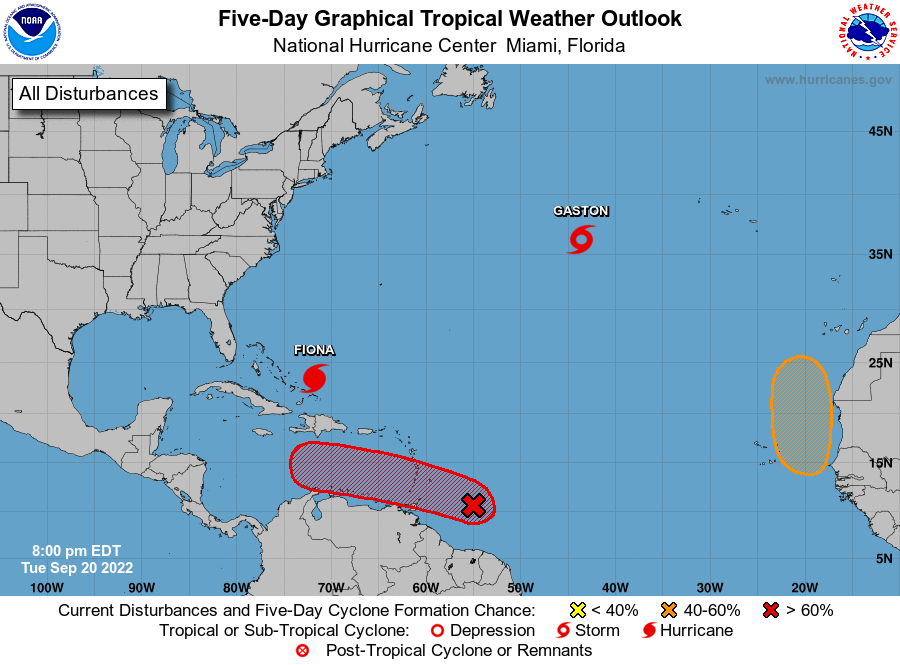
The National Hurricane Center is issuing advisories on Hurricane
Fiona, located near the Turks and Caicos islands, and on Tropical
Storm Gaston, located over the north-central Atlantic Ocean.
1. Central Tropical Atlantic:
A tropical wave is producing shower and thunderstorm activity a few
hundred miles east of the Windward Islands. The system continues to
show signs of organization and it will likely become a tropical
depression within the next two or three days. The disturbance is
forecast to move west-northwestward across the southern Windward
Islands late Wednesday and then move toward the central Caribbean
Sea late this week. Interests in the Windward Islands should closely
monitor the progress of this system as heavy rainfall and gusty
winds could affect these islands beginning on Wednesday.
* Formation chance through 48 hours...high...70 percent.
* Formation chance through 5 days...high...90 percent.
2. Eastern Tropical Atlantic:
A tropical wave is forecast to move off the west coast of Africa on
Thursday. Environmental conditions are forecast to be conducive for
at least gradual development of the system for a couple days
thereafter while the system moves slowly northward between west
Africa and the Cabo Verde Islands through the end of the week.
* Formation chance through 48 hours...low...near 0 percent.
* Formation chance through 5 days...medium...40 percent.
Public Advisories on Tropical Storm Gaston are issued under WMO
header WTNT33 KNHC and under AWIPS header MIATCPAT3.
Forecast/Advisories on Tropical Storm Gaston are issued under
WMO header WTNT23 KNHC and under AWIPS header MIATCMAT3.
Forecaster D. Zelinsky/Jelsema