ZCZC MIATWOAT ALL
TTAA00 KNHC DDHHMM
Tropical Weather Outlook
NWS National Hurricane Center Miami FL
200 PM EDT Fri Sep 2 2022
For the North Atlantic...Caribbean Sea and the Gulf of Mexico:
Active Systems:
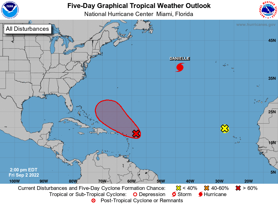
The National Hurricane Center is issuing advisories on recently
upgraded Hurricane Danielle, located about 900 miles west of the
Azores.
1. East of the Leeward Islands:
An area of low pressure located a few hundred miles east of the
Leeward Islands continues to produce disorganized showers and
thunderstorms, mainly over the eastern portion of the circulation.
Environmental conditions remain only marginally conducive, but any
additional development of the system over the next few days would
lead to the formation of a tropical depression. The disturbance is
expected to move slowly west-northwestward, toward the adjacent
waters of the northern Leeward Islands. Regardless of development,
locally heavy rains may occur over portions of the Leeward Islands
during the next couple of days, and interests in that area should
monitor the progress of the system. An Air Force Reserve Hurricane
Hunter aircraft is currently investigating the system. Additional
information on this system can be found in High Seas Forecasts
issued by the National Weather Service.
* Formation chance through 48 hours...medium...60 percent.
* Formation chance through 5 days...high...70 percent.
2. Eastern Tropical Atlantic:
Shower activity associated with a broad area of low pressure located
northwest of the Cabo Verde Islands has diminished. Significant
development is not expected as this system moves generally
west-northwestward into an area of unfavorable environmental
conditions.
* Formation chance through 48 hours...low...near 0 percent.
* Formation chance through 5 days...low...near 0 percent.
High Seas Forecasts issued by the National Weather Service
can be found under AWIPS header NFDHSFAT1, WMO header FZNT01
KWBC, and online at ocean.weather.gov/shtml/NFDHSFAT1.php
Forecaster Reinhart