ZCZC MIATWOAT ALL
TTAA00 KNHC DDHHMM
Tropical Weather Outlook
NWS National Hurricane Center Miami FL
200 PM EDT Mon Aug 29 2022
For the North Atlantic...Caribbean Sea and the Gulf of Mexico:
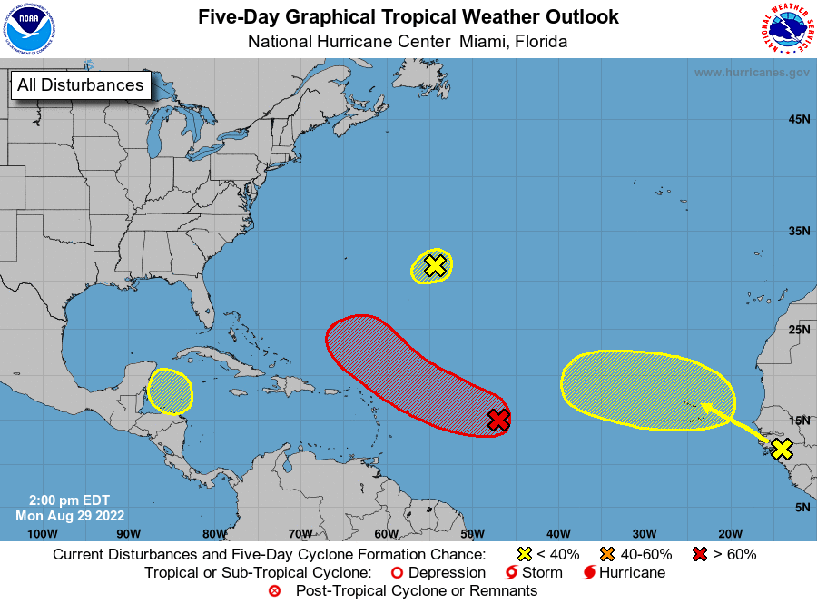
1. Central Tropical Atlantic:
A broad area of low pressure over the central tropical Atlantic
is producing a large area of disorganized cloudiness and showers.
Although environmental conditions are only marginally conducive,
some gradual development of this system is expected over the next
several days and a tropical depression is likely to form later this
week. The disturbance is forecast to move slowly toward the west
and then west-northwest at 5 to 10 mph, toward the adjacent waters
of the northern Leeward Islands. Additional information on this
system can be found in high seas forecasts issued by the National
Weather Service.
* Formation chance through 48 hours...medium...50 percent.
* Formation chance through 5 days...high...80 percent.
2. Central Subtropical Atlantic:
A small low pressure system located about 600 miles east of Bermuda
continues to produce limited shower activity. Strong upper-level
winds and dry air are expected to limit significant development of
this system while it drifts southward and southwestward over the
central Atlantic during the next couple of days, and likely
dissipate by the end of the week.
* Formation chance through 48 hours...low...10 percent.
* Formation chance through 5 days...low...10 percent.
3. Eastern Tropical Atlantic:
A tropical wave is forecast to move off the west coast of Africa
this evening or early Tuesday. Some gradual development of this
system is possible after that time while it moves generally
westward to west-northwestward across the far eastern tropical
Atlantic.
* Formation chance through 48 hours...low...10 percent.
* Formation chance through 5 days...low...30 percent.
4. Northwestern Caribbean Sea:
A trough of low pressure could develop over the northwestern
Caribbean Sea later this week. Environmental conditions could
support some slow development of the system thereafter while it
moves generally west-northwestward over the northwestern Caribbean
Sea and toward the Yucatan Peninsula of Mexico.
* Formation chance through 48 hours...low...near 0 percent.
* Formation chance through 5 days...low...10 percent.
High Seas Forecasts issued by the National Weather Service
can be found under AWIPS header NFDHSFAT1, WMO header FZNT01
KWBC, and online at ocean.weather.gov/shtml/NFDHSFAT1.php
Forecaster Pasch