ZCZC MIATWOAT ALL
TTAA00 KNHC DDHHMM
Tropical Weather Outlook
NWS National Hurricane Center Miami FL
200 PM EDT Sun Aug 28 2022
For the North Atlantic...Caribbean Sea and the Gulf of Mexico:
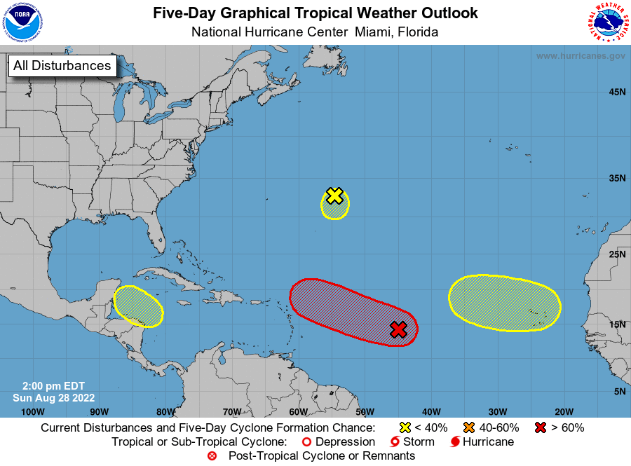
1. Central Tropical Atlantic:
Recent satellite-derived wind data indicate that a broad area of
low pressure located over the central tropical Atlantic Ocean is
producing winds to near gale force, but the circulation remains
elongated with an ill-defined center. Although environmental
conditions ahead of the system do not appear conducive for
significant development, a tropical depression, at the very least,
is likely to form later this week while moving slowly toward the
west and then west-northwest at 5 to 10 mph, toward the waters east
and northeast of the Leeward Islands.
* Formation chance through 48 hours...medium...40 percent.
* Formation chance through 5 days...high...70 percent.
2. Central Subtropical Atlantic:
A small low pressure system located about 600 miles east of Bermuda
is producing limited shower activity. Strong upper-level winds and
dry air are expected to limit significant development of this system
while it drifts southward over the central Atlantic during the next
couple of days, and the low is likely to dissipate by midweek.
* Formation chance through 48 hours...low...10 percent.
* Formation chance through 5 days...low...10 percent.
3. Northwestern Caribbean Sea:
A trough of low pressure could develop over the northwestern
Caribbean Sea during the middle part of this week. Environmental
conditions could support some slow development of the system
thereafter while it moves generally west-northwestward over the
northwestern Caribbean Sea and toward the Yucatan Peninsula of
Mexico.
* Formation chance through 48 hours...low...near 0 percent.
* Formation chance through 5 days...low...20 percent.
4. Eastern Tropical Atlantic:
A tropical wave is forecast to move off the west coast of Africa
Monday night. Some gradual development of the system is possible
after that time while it moves generally westward across the far
eastern tropical Atlantic.
* Formation chance through 48 hours...low...near 0 percent.
* Formation chance through 5 days...low...20 percent.
Forecaster Berg