ZCZC MIATWOAT ALL
TTAA00 KNHC DDHHMM
Tropical Weather Outlook
NWS National Hurricane Center Miami FL
800 PM EDT Sat Aug 27 2022
For the North Atlantic...Caribbean Sea and the Gulf of Mexico:
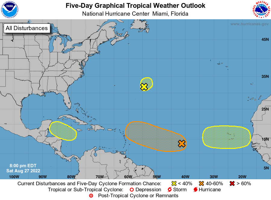
1. Central Tropical Atlantic:
Shower activity associated with an elongated area of low pressure
over the central tropical Atlantic Ocean has become a little better
organized since yesterday. Environmental conditions are forecast to
be generally favorable for additional gradual development over the
next several days, and a tropical depression could form by the
middle of next week as it moves west-northwestward at 10 to 15 mph
toward the waters east of the Leeward Islands.
* Formation chance through 48 hours...low...20 percent.
* Formation chance through 5 days...medium...50 percent.
2. Central Atlantic:
Shower activity is showing signs of organization in association
with a small low pressure area located about 600 miles east of
Bermuda. Some slow development of this system could occur during
the next two to three days while the low meanders over the central
Atlantic. After that tine, conditions are expected to become less
favorable for development.
* Formation chance through 48 hours...low...10 percent.
* Formation chance through 5 days...low...20 percent.
3. Northwestern Caribbean Sea:
A trough of low pressure could develop over the northwestern
Caribbean Sea during the early or middle part of next week.
Environmental conditions could support some slow development of the
system thereafter while it moves generally west-northwestward over
the northwestern Caribbean Sea and toward the Yucatan Peninsula of
Mexico.
* Formation chance through 48 hours...low...near 0 percent.
* Formation chance through 5 days...low...20 percent.
4. Eastern Tropical Atlantic:
A tropical wave is forecast to move off the west coast of Africa
early next week. Some gradual development of the system is possible
during the middle of next week while it moves generally westward
across the far eastern tropical Atlantic.
* Formation chance through 48 hours...low...near 0 percent.
* Formation chance through 5 days...low...20 percent.
Forecaster Beven