ZCZC MIATWOAT ALL
TTAA00 KNHC DDHHMM
Tropical Weather Outlook
NWS National Hurricane Center Miami FL
800 PM EDT Thu Jun 30 2022
For the North Atlantic...Caribbean Sea and the Gulf of Mexico:
Active Systems:
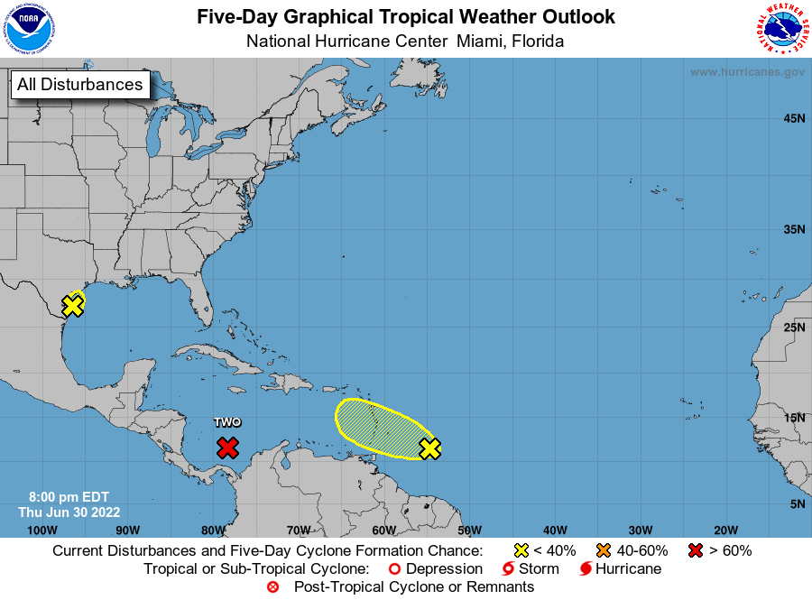
The National Hurricane Center is issuing advisories on Potential
Tropical Cyclone Two, located over the southwestern Caribbean Sea.
* Formation chance through 48 hours...high...90 percent.
* Formation chance through 5 days...high...90 percent.
1. Western Gulf of Mexico:
Satellite and radar imagery, along with reports from an Air Force
Reserve Hurricane Hunter aircraft, indicate there has been little
change in the strength and organization of the low pressure near
the southern coast of Texas during the last several hours. The
disturbance is forecast to move slowly northward and inland over
southeastern Texas tonight. While slow development is still
possible until the low moves inland, the chances of a tropical
depression forming are decreasing. Regardless of development,
heavy rain and associated flooding are possible along portions of
the Texas coast for the next two days. For more information about
the potential for heavy rain and flooding, please see products
issued by your National Weather Service office.
* Formation chance through 48 hours...low...30 percent.
* Formation chance through 5 days...low...30 percent.
2. Western Tropical Atlantic:
A tropical wave located a few hundred miles east of the Windward
Islands is producing disorganized showers and thunderstorms. Any
development of this system should be slow to occur while the wave
moves west-northwestward during the next day or two. The wave is
forecast to move over the Windward Islands on Friday and then over
the eastern Caribbean Sea by the weekend, where further development
is unlikely due to unfavorable environmental conditions.
* Formation chance through 48 hours...low...10 percent.
* Formation chance through 5 days...low...10 percent.
Forecaster Beven