ZCZC MIATWOAT ALL
TTAA00 KNHC DDHHMM
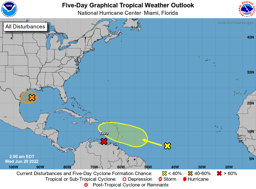
Tropical Weather Outlook
NWS National Hurricane Center Miami FL
200 AM EDT Wed Jun 29 2022
For the North Atlantic...Caribbean Sea and the Gulf of Mexico:
East of the Windward Islands:
The National Hurricane Center is issuing advisories on Potential
Tropical Cyclone Two, located over the eastern Caribbean Sea to the
north of Venezuela.
* Formation chance through 48 hours...high...80 percent.
* Formation chance through 5 days...high...90 percent.
1. Northern Gulf of Mexico:
An area of low pressure centered over the northwestern Gulf of
Mexico continues to produce disorganized showers and thunderstorms.
This system is forecast to move slowly westward or west-
southwestward and approach the coast of Texas during the next day or
two. Slow development of the low is possible, and it could become a
short-lived tropical depression near the coast before it moves
inland tonight or Thursday. Regardless of development, heavy rain
will be possible along portions of the Texas coast later this week.
For more information about the potential for heavy rain, please see
products issued by your National Weather Service office.
* Formation chance through 48 hours...medium...40 percent.
* Formation chance through 5 days...medium...40 percent.
2. Central Tropical Atlantic:
A tropical wave located over the central tropical Atlantic is
producing disorganized showers and a few thunderstorms. This system
is forecast to interact with another tropical wave over the next
couple of days, and some gradual development is possible later this
week. The overall system is forecast to be near the Windward
islands by the weekend while it moves west-northwestward at about
15 mph.
* Formation chance through 48 hours...low...10 percent.
* Formation chance through 5 days...low...30 percent.
Forecaster Papin