ZCZC MIATWOAT ALL
TTAA00 KNHC DDHHMM
Tropical Weather Outlook
NWS National Hurricane Center Miami FL
800 AM EDT Thu Jun 2 2022
For the North Atlantic...Caribbean Sea and the Gulf of Mexico:
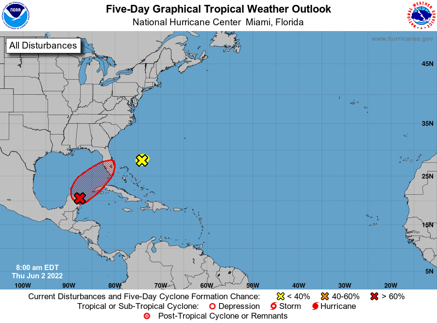
Near the Yucatan Peninsula and Southeastern Gulf of Mexico:
A broad area of low pressure located over the northeastern portion
of the Yucatan Peninsula continues to produce a large area of
disorganized showers and thunderstorms over the northwestern
Caribbean Sea and Yucatan Peninsula. Despite strong upper-level
winds, this system is likely to become a tropical depression or
tropical storm while it moves slowly northeastward over the
northwestern Caribbean Sea and southeastern Gulf of Mexico during
the next day or two. Interests in western Cuba, the Florida Keys,
and the Florida Peninsula should monitor the progress of this
system, and tropical storm watches or warnings could be required
for some of these areas later today.
1. Regardless of development, areas of heavy rainfall are likely
across portions of the Yucatan Peninsula and western Cuba during
the next day or so, spreading across southern and central Florida
and the Florida Keys Friday and Friday night, and the northwestern
Bahamas on Saturday. These heavy rains could cause scattered to
numerous flash floods across South Florida and the Florida Keys.
* Formation chance through 48 hours...high...80 percent.
* Formation chance through 5 days...high...80 percent.
2. Southwestern Atlantic:
Shower activity associated with a weak surface trough located about
200 miles east-northeast of the northwestern Bahamas has
diminished, and upper-level winds remain strong in the area.
Development of this system is not expected while it moves
northeastward at 5 to 10 mph over the southwestern Atlantic during
the next couple of days.
* Formation chance through 48 hours...low...near 0 percent.
* Formation chance through 5 days...low...near 0 percent.
Forecaster Beven