ZCZC MIATWOAT ALL
TTAA00 KNHC DDHHMM
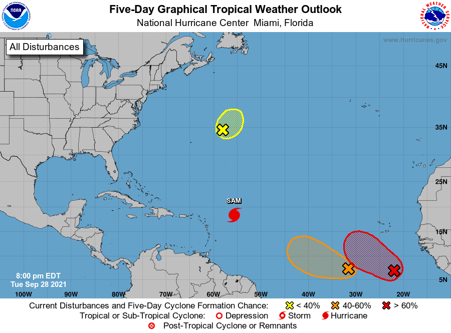
Tropical Weather Outlook
NWS National Hurricane Center Miami FL
800 PM EDT Tue Sep 28 2021
For the North Atlantic...Caribbean Sea and the Gulf of Mexico:
The National Hurricane Center is issuing advisories on Hurricane
Sam, located several hundred miles east of the northern Leeward
Islands.
1. Recent satellite-derived surface wind data indicate that the low
pressure system located over the far eastern tropical Atlantic
several hundred miles south of the Cabo Verde Islands is gradually
becoming better defined. The associated showers and thunderstorms
are showing signs of organization, and a tropical depression is
expected to form during the next day or so while the disturbance
moves west-northwestward at 10 to 15 mph over the eastern tropical
Atlantic.
* Formation chance through 48 hours...high...90 percent.
* Formation chance through 5 days...high...90 percent.
2. Showers and thunderstorms remain disorganized in association with a
a broad area of low pressure located several hundred miles southwest
of the Cabo Verde Islands. Environmental conditions are conducive
for gradual development, and a tropical depression could still form
during the next couple of days if the disturbance does not get
absorbed into the stronger low pressure system located to its east.
The broad low is expected to move slowly west-northwestward to
westward over the central tropical Atlantic during the next few
days.
* Formation chance through 48 hours...medium...60 percent.
* Formation chance through 5 days...medium...60 percent.
3. A well-defined low pressure area associated with the remnants of
Peter is located several hundred miles east-northeast of Bermuda.
The associated shower and thunderstorm activity remains limited,
and the chances of this system becoming a short-lived tropical
depression or storm appear to be decreasing. This system is expected
to move northeastward at about 10 mph into a region of very strong
upper-level winds on Wednesday. Additional information on this
system can be found in High Seas Forecasts issued by the National
Weather Service.
* Formation chance through 48 hours...low...30 percent.
* Formation chance through 5 days...low...30 percent.
High Seas Forecasts issued by the National Weather Service can be
found under AWIPS header NFDHSFAT1, WMO header FZNT01 KWBC, and
online at ocean.weather.gov/shtml/NFDHSFAT1.php
Forecaster Stewart