ZCZC MIATWOAT ALL
TTAA00 KNHC DDHHMM
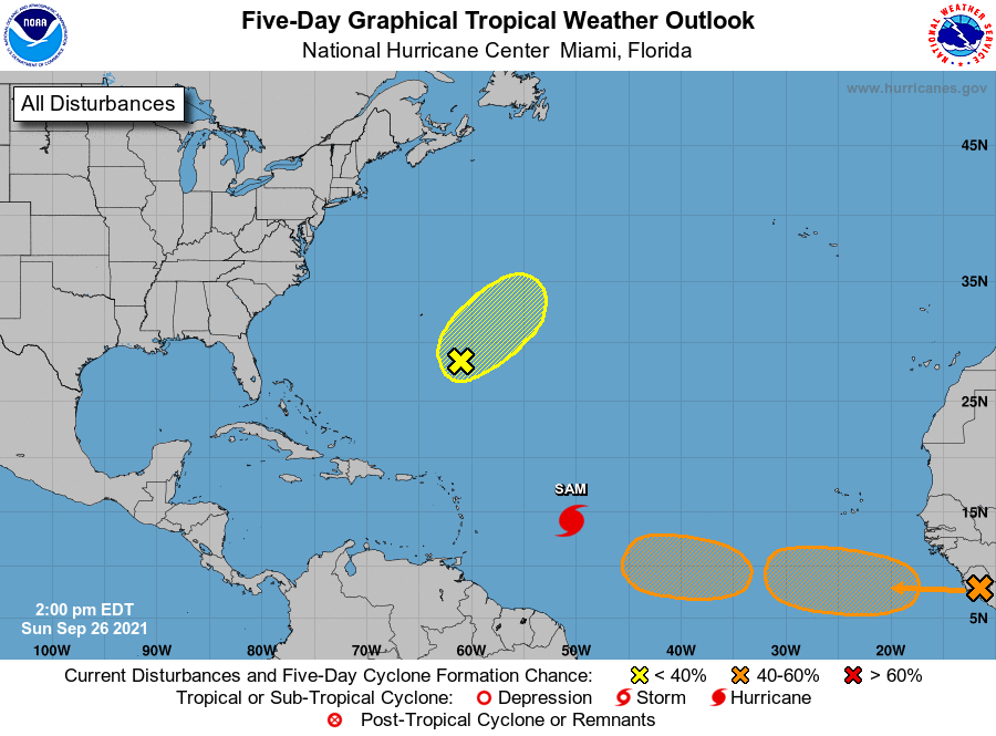
Tropical Weather Outlook
NWS National Hurricane Center Miami FL
200 PM EDT Sun Sep 26 2021
For the North Atlantic...Caribbean Sea and the Gulf of Mexico:
The National Hurricane Center is issuing advisories on Hurricane
Sam, located about 850 miles east-southeast of the northern Leeward
Islands.
1. Showers and thunderstorms have become a little better organized
today in association with a surface trough that is the remnants of
Peter. Upper-level winds are marginally conducive for some slow
development of this disturbance over the next couple of days as it
moves northeastward at about 10 mph. By midweek, environmental
conditions are expected to become unfavorable for further
development.
* Formation chance through 48 hours...low...30 percent.
* Formation chance through 5 days...low...30 percent.
2. A tropical wave is expected to move off the west coast of Africa on
Monday. Environmental conditions are forecast to be conducive for
gradual development thereafter, and a tropical depression could form
by midweek while the system moves westward to west-northwestward at
10 to 15 mph over the far eastern tropical Atlantic.
* Formation chance through 48 hours...low...10 percent.
* Formation chance through 5 days...medium...60 percent.
3. A broad area of low pressure is expected to form over the eastern or
central tropical Atlantic early this week, to the west of the
tropical wave that will be moving off the coast of Africa.
Thereafter, environmental conditions are forecast to support some
development of this disturbance, and a tropical depression could
form by late this week while it moves westward at 5 to 10 mph.
* Formation chance through 48 hours...low...near 0 percent.
* Formation chance through 5 days...medium...50 percent.
Forecaster Latto