ZCZC MIATWOAT ALL
TTAA00 KNHC DDHHMM
Tropical Weather Outlook
NWS National Hurricane Center Miami FL
200 PM EDT Fri Sep 24 2021
For the North Atlantic...Caribbean Sea and the Gulf of Mexico:
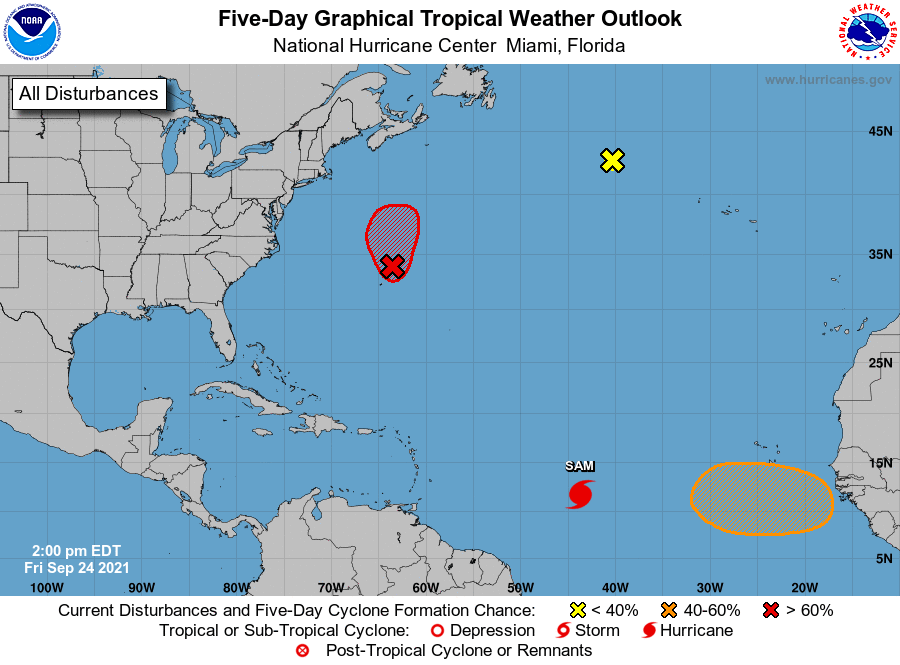
The National Hurricane Center is issuing advisories on Hurricane
Sam, located about 1300 miles east-southeast of the northern Leeward
Islands.
1. Surface observations and recent satellite wind data indicate that a
surface low located a couple hundred miles north-northeast of
Bermuda is gradually becoming better defined as it interacts with an
upper-level trough. This system is producing winds of 40 to 45 mph
north of the low center and additional development into a
subtropical or tropical storm appears likely. Advisories could be
initiated as soon as this afternoon as the system moves slowly
toward the north-northwest over the next day or so. Additional
information on this system, including gale warnings, can be found in
High Seas Forecasts issued by the National Weather Service.
* Formation chance through 48 hours...high...70 percent.
* Formation chance through 5 days...high...70 percent.
2. A gale-force, non-tropical low pressure system, the remnants of
Odette, is located less than 600 miles west of the
westernmost Azores. Showers and thunderstorms have mostly
dissipated near the low, and strong upper-level winds are now
expected to prevent further development as this system moves
gradually southward until dissipation. Additional information on
this system, including gale warnings, can be found in High Seas
Forecasts issued by the National Weather Service.
* Formation chance through 48 hours...low...near 0 percent.
* Formation chance through 5 days...low...near 0 percent.
3. A tropical wave is expected to move off the west coast of Africa by
the end of this weekend. Thereafter, environmental conditions are
forecast to be conducive for gradual development, and a tropical
depression could form by the middle of next week while the system
moves westward at 10 to 15 mph over the far eastern tropical
Atlantic.
* Formation chance through 48 hours...low...near 0 percent.
* Formation chance through 5 days...medium...50 percent.
High Seas Forecasts issued by the National Weather Service can be
found under AWIPS header NFDHSFAT1, WMO header FZNT01 KWBC, and
online at ocean.weather.gov/shtml/NFDHSFAT1.php
Forecaster Papin